Key Takeaways
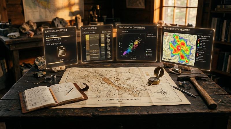
- The task today: Geologists who search for mineral deposits use AI in mineral exploration to read historical reports and spot patterns in rock data, and GeoCluster is a browser-based AI agent that investigates these datasets without any software setup.
- Data quality sets the limit: Machine learning models can only find patterns in the data they receive, so messy files or missing records create false targets before any analysis runs.
- Field validation is still limited: Published research shows that while many algorithms work on historical datasets, very few predictions have been tested by drilling new holes in the field.
- Traceability protects against black boxes: A reliable AI prediction must link directly back to the physical rock measurements that created it, so geologists can verify why a target was chosen.
TL;DR
Artificial intelligence in mineral exploration helps geologists process old documents, log rock core and spot patterns in vast geochemical surveys. However, machine learning algorithms suggest targets while human geologists make the drilling decisions, because very few automated predictions have been confirmed in the field. This guide explains where AI works across the exploration workflow and how tools like GeoCluster keep every prediction linked to verifiable physical measurements.
What does AI in mineral exploration mean?
In modern geology, AI in mineral exploration applies machine learning algorithms to geological datasets. These datasets include drillhole logs, multielement geochemistry, geophysical grids and legacy maps. The technology automates repetitive data compilation and identifies complex spatial patterns. As a result, exploration geologists can rank prospective targets for drill testing across regional mineral systems.
This practical guide addresses exploration geologists, project managers and geoscientists. Exploration teams work with four distinct computational tools:
- Document extraction through language models to parse historical PDFs.
- Visual classification of drill core imagery using computer vision.
- Classical multivariate statistics, including Median Absolute Deviation and spatial filtering.
- Machine learning algorithms, such as K-means clustering, Random Forests and dimensionality reduction.
Geologists must also distinguish between four related concepts that industry discussions often confuse:
- A cluster is an unsupervised grouping of samples that share similar multi-element chemistry under specific algorithm settings.
- An anomaly is an analytical measurement or spatial pattern that departs significantly from a defined geochemical baseline distribution.
- A prospectivity score is a numerical estimate of relative geological favourability calculated from model weights and spatial layers.
- A mineral deposit is a physical, three-dimensional geological body confirmed by physical drilling, sampling and structural mapping.
Exploration teams frequently pair these statistical methods with specialised ai mining software to connect historical archives directly to active drilling models without manual data entry.
Where AI for mineral exploration is used across workflows
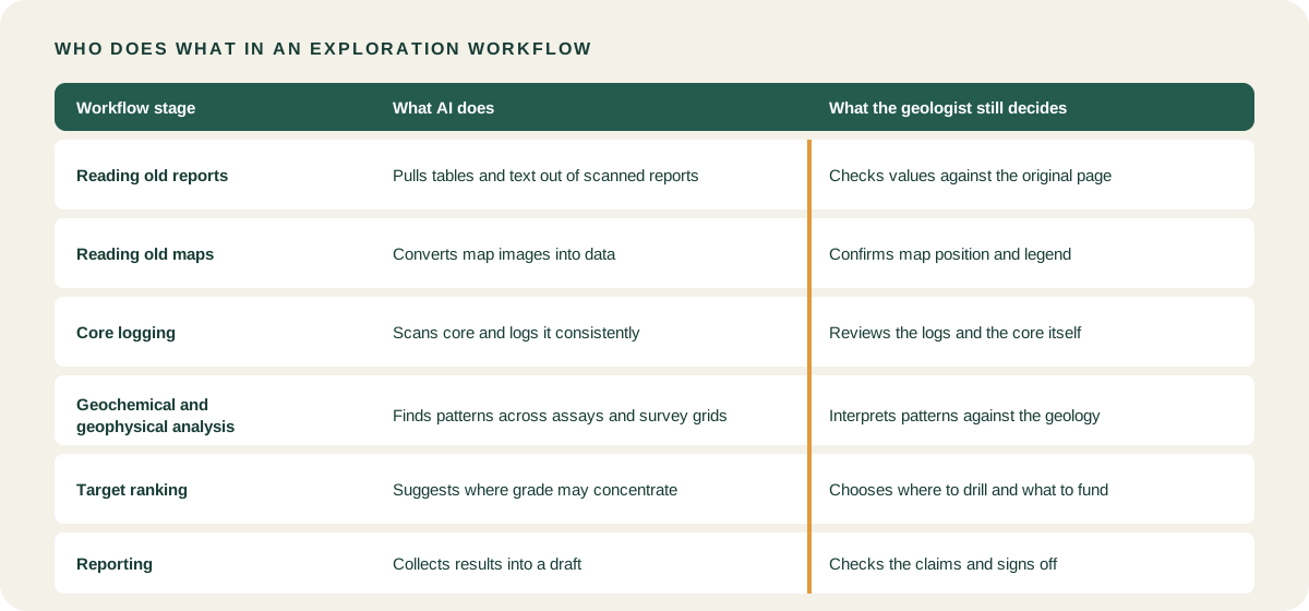
Modern machine learning does not automate exploration end-to-end. Instead, ai for mineral exploration delivers targeted value across five discrete operational stages. Within each stage, using AI in mineral exploration allows teams to process complex geological inputs while maintaining scientific control over interpretations.
| Exploration stage | What AI does | What AI needs | Core method used | What the geologist verifies |
|---|---|---|---|---|
| Archival ingestion | Extracts tabular data and vectorises old map sheets | Scanned PDF reports, raster map sheets, OCR text | Document parsing, vision models, raster vectorisation | Alignment against original paper certificates and map grids |
| Core logging | Classifies rock textures and estimates mineralogy | High-resolution core photos, hyperspectral imagery | Convolutional neural networks, spectral unmixing | Visual validation against physical drill core in the shed |
| Geochemical analysis | Groups multielement assays and isolates pathfinder anomalies | Clean tabular assay certificates with detection limits | Non-parametric statistics (MAD), clustering (K-means, DBSCAN) | Geological plausibility of alteration pathfinder associations |
| Geophysics processing | Highlights density contrasts and structural lineaments | Gridded magnetic, gravity and radiometric surveys | Spatial filtering, edge detection, automated inversion | Concordance with known regional structures and fault kinematics |
| Target generation | Combines multi-commodity layers into prospectivity maps | Co-registered geological, structural and assay grids | Supervised classification (Random Forests), weights of evidence | Structural sense, access constraints and field validation |
Core scanning and automated mineralogy
In core sheds, automated imaging setups speed up routine logging. Sensor setups using core scanning and XRF tools capture continuous mineralogical variations before core is cut for chemical assaying.
Automated logging algorithms identify mineral phases and fabric boundaries. However, experienced geologists must inspect the physical drill core directly. They must confirm whether detected minerals represent hydrothermal alteration or unmineralised host rock.
Regional prospectivity mapping
At regional scales, algorithms combine geophysics, faults and geochemistry into prospectivity heatmaps. Generating these heatmaps represents one of the most mature applications of AI in mineral exploration. These layers help exploration managers identify prospective ground across large tenure packages.
Regional prospectivity modelling stacks disparate datasets with varying spatial supports and resolutions. For example, airborne magnetic grids may have cell sizes of 50 metres. In contrast, stream sediment assays represent irregular catchment polygons, and drillholes represent discrete metre-scale intervals. Geologists must harmonize these spatial layers through careful resampling and interpolation. Teams must carry spatial uncertainty into the final target ranking rather than treating interpolated grids as verified ground truth.
The data you need before using AI in mineral exploration
Data quality and spatial integrity govern algorithmic targeting success. If historical spreadsheets contain inconsistent coordinate datums or unstandardised rock codes, machine learning algorithms output misleading patterns.
Historical reports are a common source of data friction. Exploration teams often deploy PDF table extraction to parse legacy drilling records into structured tabular formats without manual typing errors.
Scanned cartography presents similar challenges. Modern workflows for digitising old geological maps turn raster imagery into georeferenced polygon and line layers that algorithms can query spatial boundaries against.
A practical example of this preparation is AI recovering borehole data from Soviet-era geological maps, where vectorisation extracted historical coordinates to populate a modern exploration database.
Historical archives and coordinate transformations
Digitisation generates candidate data rather than verified ground truth. Historical maps suffer from paper shrinkage, hand-drafting distortions and scanning artifacts. Geologists must cross-check extracted borehole collars against original paper reports. Furthermore, teams must verify georeferencing root-mean-square residuals against known ground control points before running machine learning models.
Coordinate reference systems must also be handled with precision. A coordinate reference system combines a geodetic datum with a map projection system. Common datums include WGS84, GDA2020 and NAD83, while UTM zones represent map projections. Storing coordinates without an explicit datum creates severe mapping errors. Assigning a new coordinate system without mathematical transformation introduces spatial offsets of tens to hundreds of metres.
Assay detection limits and analytical qualifiers
In practical ai mineral exploration projects, maintaining separate columns for raw values, analytical qualifiers and detection limits ensures transparent data cleaning. Primary databases must never collapse distinct assay states into a single numeric zero or dummy value. A measured value below analytical detection is a left-censored measurement. Similarly, an unassayed interval indicates pending analysis or lost core, and a failed quality control sample denotes an invalid batch.
Primary database tables must preserve raw laboratory values and qualifiers verbatim. Downstream statistical routines can then apply justifiable substitutions, such as half the detection limit or regression on order statistics. This separation prevents teams from corrupting authoritative baseline records.
Machine learning in mineral exploration: core methods
When deploying AI in mineral exploration, geologists meet four primary families of machine learning algorithms. Each family suits distinct analytical questions and data structures.
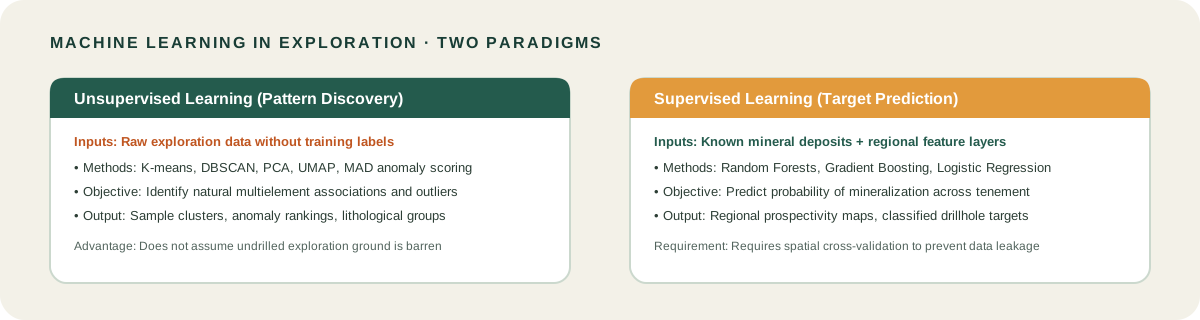
Unsupervised clustering and dimensionality reduction
Clustering algorithms group geochemical samples by multi-element similarity in feature space. Common algorithms include K-means and DBSCAN. They help geologists map alteration halos across thousands of multielement assays without imposing prior assumptions. However, clusters represent mathematical groupings, not verified orebodies. A distinct cluster may reflect an unmapped lithological unit or weathering profile rather than economic mineralisation.
Dimensionality reduction algorithms project multi-element assays into lower-dimensional spaces. Common methods include Principal Component Analysis (PCA) and Uniform Manifold Approximation and Projection (UMAP). PCA identifies orthogonal linear combinations that explain maximum sample variance. In contrast, UMAP preserves local neighbourhood topology.
Importantly, these components do not automatically represent mineralisation processes. Variance is frequently dominated by major rock-forming elements, regional lithological contacts or weathering effects. Because geochemical assays represent compositional data constrained to a constant sum, geologists should apply log-ratio transformations. Applying the centred log-ratio transformation before computing principal components prevents spurious correlations.
Anomaly scoring and supervised prospectivity
Statistical anomaly scoring methods identify sample values that depart significantly from a defined baseline. Common methods include standardised Z-scores and Median Absolute Deviation (MAD). Because geological data distributions are typically skewed, MAD provides a non-parametric measure of dispersion resistant to extreme outlier values. Geologists calculate MAD within distinct host-rock lithologies:
MAD = median(|x_i - median(x)|)
For a normal distribution, multiplying MAD by 1.4826 estimates the normalized dispersion. An anomaly threshold for pathfinder elements is typically set at two or three normalized MAD units above the lithological median. For example, in an orogenic gold system, geologists establish arsenic and antimony baselines separately for mafic volcanics and sedimentary units. A sample with 35 ppm arsenic represents background in a black shale, but indicates an anomaly in an adjacent basalt.
Supervised classification models learn multi-layer patterns from known mineral deposits. A common choice is Random Forests, which searches for matching signatures across regional datasets. Training supervised models requires careful handling of the positive-unlabelled problem. Positive training labels represent known deposits or mineralised drillholes, but un-drilled ground cannot be assumed to be barren. Treating un-drilled ground as confirmed negative samples introduces severe bias.
Furthermore, standard random cross-validation leads to spatial data leakage. Samples clustered around historical mines leak into both training and validation sets. Teams must use spatial block cross-validation, segregating training and test sets into geographically separate blocks. Teams should evaluate performance using precision-recall metrics rather than standard accuracy.
To explore these techniques interactively, geologists use dedicated geochemical clustering and anomaly tools that run these algorithms directly within visual mapping interfaces.
How geologists verify AI in mineral exploration results
Exploration drilling requires significant financial commitments. Therefore, verifying the validity of AI in mineral exploration predictions is mandatory before recommending drill programmes.
Evidence traceability and reproducibility
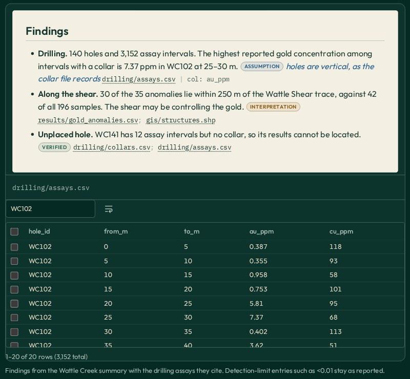
First, demand complete evidence traceability. In an auditable machine learning workflow, an anomaly score must connect through an unbroken provenance chain. This chain includes the original laboratory assay certificate ID, sample identifier, drillhole interval depth, raw measurement and detection qualifier. It also records preprocessing transformations, algorithm version, hyperparameters, random seed and geologist sign-off notes.
Second, understand reproducibility requirements. Many machine learning algorithms include stochastic components. Examples include random centroid initialisation in K-means, random feature selection in Random Forests, and stochastic gradient descent in UMAP. Exact reproducibility requires fixing random seeds and documenting software environments. This ensures that repeated runs on identical data yield consistent rankings within documented computational tolerances.
Third, compare prospective predictions against known mineral system models. A legitimate exploration target should align with structural fault corridors, lithological contacts and expected alteration mineralogy.
Retrospective case validation and agent harnesses
The Coe Fairbairn case study documents this validation approach, featuring AI rediscovering a rare earth deposit from archival data by evaluating historical exploration data as a testable hypothesis.
In that retrospective study across Western Australia, automated clustering evaluated historical multi-element drilling records. The algorithms identified prospective rare earth element intervals that historical paper reports had overlooked. The algorithmic output served as a focused exploration hypothesis for subsequent field planning rather than an autonomous discovery of an orebody.
Modern research explores recursive self-improvement to refine algorithmic pipelines over time, but human geological oversight remains mandatory before drilling permits are signed.
When evaluating automated platforms, geologists often rely on a geology AI agent to inspect the audit trail connecting raw sample records to generated prospectivity scores.
GeoCluster, developed by Eigenform, operates as a browser-based geological investigation harness. Functioning as an exploratory analysis layer alongside existing databases, it ingests structured tables, including CSV, GeoJSON and Shapefiles. The system computes anomaly scores and clustering routines, presenting results in interactive map and table views. It does not replace primary databases or discover deposits autonomously. Instead, it accelerates data exploration while preserving an audit trail back to source measurements.
Auditable spatial boundaries and evidence traceability
Grounding AI analysis in verifiable exploration data requires strict spatial boundary validation and provenance tracking. Exploration tools must validate bounding box coordinates in canonical coordinate systems like EPSG:4326, verifying that coordinates fall within defined geographic limits before executing spatial calculations or querying regional datasets. This boundary validation guarantees that analytical models evaluate records strictly within the designated tenement or project area. While automated validators constrain data ranges, geologists must still inspect the underlying records to ensure that generated exploration hypotheses remain fully supported by physical measurements.
A practical first project: ranking geochemical anomalies
For teams beginning to use AI in mineral exploration, starting with a bounded, low-risk project on data you already understand ensures that computational techniques remain grounded in geological reality.
Begin by selecting a clean soil or drillhole geochemical survey with at least 500 multielement samples. A 500-sample dataset provides a practical starting point. It offers sufficient statistical stability to calculate reliable medians and MAD thresholds across three to five distinct lithological units without small-sample distortion. Export the table containing sample coordinates, lithology codes and raw elemental assays.
Next, load the dataset into geology data analysis software that operates directly in your web browser without requiring complex server installations.
Step-by-step geochemical ranking pipeline
Follow these practical steps to evaluate the results:
- Clean detection thresholds: Verify that raw assay values and laboratory qualifiers (
<) remain in your master table, while setting below-detection values to half the detection limit in your analysis extract. - Calculate background baselines: Group samples by host rock lithology to establish local background medians and dispersion for target elements.
- Compute anomaly scores: Calculate Median Absolute Deviation scores for key pathfinder elements, such as arsenic, antimony and bismuth in gold systems, or copper and molybdenum in porphyry systems, setting anomaly cutoffs at three normalized MAD units above the lithological median.
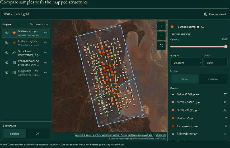
- Inspect spatial clusters: View the ranked anomaly clusters on an interactive map, checking whether elevated scores cluster along mapped fault trends or lithological contacts.
- Verify against physical samples: Pull the original drill core or sample pulps for the highest-ranked cluster to confirm visible sulphide mineralisation and alteration assemblages.
The expected deliverables of this exercise include a versioned ranked-sample table, an interactive GIS map layer of anomaly clusters, a documented parameter log detailing baselines and random seeds, and physical core inspection notes. The project succeeds when the analysis is completely reproducible and high-ranked samples correlate with visible hydrothermal alteration in physical rock samples.
Choosing AI tools for mineral exploration
When selecting software for AI in mineral exploration, avoid platforms that lock your data into proprietary closed formats.
Prioritise systems that read standard file formats such as CSV, Shapefile and GeoTIFF, and ensure the vendor provides transparent export mechanisms for all intermediate calculations and parameters. A detailed breakdown of commercial and open-source platforms is available in our overview of best AI tools for geology across exploration workflows.
What to watch for: limits and field validation gaps
Deploying AI in mineral exploration requires a clear understanding of its operational boundaries and empirical limitations.
Academic review findings and sampling biases
- Limited field validation in academic literature: An extensive systematic academic review in Earth-Science Reviews by Yang, Zuo and Kreuzer (2024, Vol. 250, 104689) evaluated machine learning in mineral prospectivity mapping across more than 200 published studies. The authors found that despite high reported statistical accuracies on historical training data, real-world field validation through prospective diamond drilling remains exceptionally rare. Most published models perform retrospective validation on known deposits rather than testing blind targets in the field.
- Sampling bias and historical clustering: Algorithms frequently highlight areas surrounding historical mines because historical drilling was clustered there, mistaking human exploration density for geological favourability.
- False precision: A prospectivity index calculated to four decimal places does not make an uncertain geological contact or sparse geochemical grid more accurate.
- Negative evidence: The absence of geochemical anomalies in an un-drilled basin indicates a lack of sampling, not the absence of mineralisation. Un-drilled ground must never be treated as confirmed barren ground.
FAQs
What is AI in mineral exploration?
In mineral exploration, AI applies machine learning and statistical algorithms to geological datasets, including drillhole databases, geochemistry, geophysics and legacy maps. It automates data extraction, detects subtle alteration patterns and prioritises prospective targets for follow-up drilling, helping exploration teams test hypotheses across regional mineral systems without replacing human geological judgement.
How is AI used in mineral exploration?
AI assists geologists across five primary stages: parsing tables from historical reports, classifying drill core imagery, identifying multielement geochemical anomalies, filtering structural geophysics and generating regional prospectivity maps. In each workflow stage, algorithms highlight statistical associations and rank prospective targets, while exploration geologists verify interpretations against physical rock samples and field evidence.
What data do I need to use AI in exploration?
You need structured exploration datasets with verified spatial coordinates and documented reference datums. Standard inputs include drillhole collars, downhole deviation surveys, multielement assay certificates with preserved detection limits, lithological logs and geophysical grids. Consistent column naming, valid coordinate systems and auditable data cleaning are essential prerequisites for reliable algorithmic analysis.
Can AI find mineral deposits?
AI cannot find mineral deposits autonomously. Machine learning algorithms identify statistical correlations in existing exploration data and highlight prospective anomalies for field follow-up. Only physical diamond drilling, surface trenching and systematic core assaying can determine whether an algorithmic target represents economic mineralisation with sufficient grade, continuity and tonnage to justify development.
Is machine learning accurate for exploration targeting?
Machine learning accuracy depends heavily on data quality, spatial sampling density and geological context. While algorithms excel at multivariate pattern recognition, published scientific reviews show that prospective field validation through new diamond drilling remains rare. Geologists must verify that automated prospectivity heatmaps align with known structural controls and hydrothermal mineralisation models.
Will AI replace exploration geologists?
No. Machine learning automates repetitive data compilation, geochemical clustering and spatial grid filtering, but algorithms lack geological reasoning. Experienced exploration geologists remain essential for interpreting complex structural histories, evaluating hydrothermal alteration in physical core, defining geological domains, designing drilling programmes and making capital allocation decisions under deep geological uncertainty.
How do I start using AI on my exploration data?
Start with a bounded, low-risk project on a multielement geochemical survey you already understand. Clean your assay tables, preserve original laboratory detection limits, and compute Median Absolute Deviation scores within distinct lithology groups. Run unsupervised clustering in browser-based analysis software to identify pathfinder vectors before scaling up to regional prospectivity models.
Try It With Geocluster
Open GeoCluster to explore geochemical datasets, rank anomalies and evaluate multivariate exploration data in your web browser with an AI agent.
To compare software options across the industry, read our guide on best AI tools for geology for modern exploration teams.