Key Takeaways
- The task today: Geologists who search for new mineral deposits use AI mining tools to read old reports and maps and to spot patterns in lab and survey data, and GeoCluster is a browser-based AI agent for geological investigation that works with these kinds of data without any installation.
- Where it stops: AI suggests places to look, and a geologist still checks every suggestion, because most of the evidence so far comes from demonstrations rather than results tested in the field.
- How to trust a result: A result is only as trustworthy as your ability to trace it back to the measurement it came from. If you cannot do that, the tool is a black box.
- What GeoCluster does about it: It keeps raw measurements separate from interpretation, so a geologist can see which data supports a result.
TL;DR
Finding new mineral deposits means working through old reports, maps, rock chemistry tables and survey data. AI mining tools speed up that data work and help rank where to look next, but they suggest and the geologist decides. Most published evidence is still demonstration rather than tested field results, so the practical test for any tool is whether you can trace each result back to the measurement behind it. GeoCluster is a browser-based AI agent for geological investigation built around that idea.
What is AI mining?
AI mining, in this article, means using artificial intelligence in mineral exploration: software that reads geological reports and maps, finds patterns in geochemical and geophysical data, and helps rank places to investigate. The term is also used for two other things, AI that runs mine operations and cryptocurrency mining, which this article does not cover.
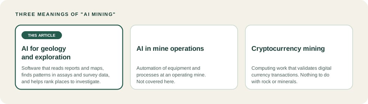
Mine operations AI, such as automation of equipment, is a separate field. Cryptocurrency mining has nothing to do with geology at all. If you landed here looking for either, this is the wrong page. For AI geology work, the useful question is narrower: which parts of the exploration workflow can AI speed up today, and which parts still need a person.
What AI mining does for geologists today
The pressure behind AI in mineral exploration is partly a workforce one. A Mining Technology feature on whether AI can mitigate the global shortage of geologists reports employment projections from the American Geosciences Institute and the US Bureau of Labor Statistics. They put retirements at about 27% of the US geoscience workforce by 2029 and forecast a shortage of 130,000 geologists by the end of the decade. With fewer people and more data, tools that take over repetitive data work become attractive.
The same article quotes Rupert Osborn, a technical product manager at the software company Micromine, who names the areas where AI most affects geologists: geological and grade modelling, logging and analysing drill holes with core scanning machines, and possibly identifying new targets.
Stage by stage: what AI does and what the geologist decides
The table below follows the exploration workflow and separates what AI does from what the geologist still decides.
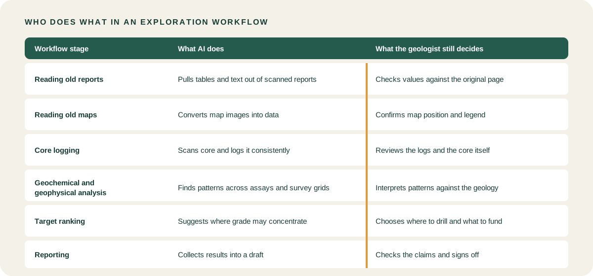
| Workflow stage | What AI does | What the geologist still does |
|---|---|---|
| Reading old reports | Pulls tables and text out of scanned reports, as in PDF table extraction | Checks extracted values against the original page |
| Reading old maps | Converts map images into data, as in digitising old geological maps | Confirms the map position and the legend |
| Core logging | Uses core scanning machines to log and analyse drill holes, as covered in core scanning and XRF tools | Reviews the logs and the core itself |
| Geochemical and geophysical analysis | Finds patterns across assays and survey grids | Interprets the patterns against the geology |
| Target ranking | Suggests where grade may be concentrated | Chooses where to drill and what to fund |
| Reporting | Collects results into a report draft | Checks the claims and signs off |
Map digitising is where the effect is easiest to see. Eigenform’s case study on AI recovering borehole data from Soviet-era geological maps shows how hand-drawn borehole symbols on scanned sheets became usable coordinates once the maps were vectorised.
Target ranking in practice
An AusIMM Bulletin article, Confidence at every stage, describes neural networks that learn from drillhole assays, geochemistry and spatial data to predict where grade is likely to concentrate. Its author, Victor Cha, is a product strategy manager at Micromine, and the examples are demonstrations of the vendor’s own tool, not project results. In one, geologists simulated an early-stage drilling scenario on a public gold dataset, and the model highlighted a high-grade trend that was not easy to see by eye.
Treat that as a demonstration of what the technique can do, not as a record of project results. The article also describes using an AI model as an independent second opinion next to a conventional estimate, with geologists comparing the two and interpreting the differences.
What AI mining cannot do yet
AI tools do not discover deposits by themselves. They find patterns in the data they are given, and they cannot judge whether a pattern makes geological sense. A 2024 review in Earth-Science Reviews by Yang, Zuo and Kreuzer, Artificial intelligence for mineral exploration, found that AI has not yet been widely tested in real exploration settings. Many published methods work on datasets but have not run in real exploration programmes.
Three limits follow from that.
- Limited field validation. A model that ranks targets well on historical data has yet to show it can find ore in the field.
- Dependence on data quality. Mining Technology quotes Jaime Livesey, chief executive of the Australian Institute of Geoscientists (AIG), warning that decisions made on unreliable data could be wrong, and that AI may struggle with the nuances of geology and oversimplify them.
- Results that look confident but are wrong. A model returns an answer whether or not the data behind it is good. The same article quotes Graham Lederer, a US Geological Survey geologist, warning that early-career staff will find it harder to judge whether automated tools produce quality work.
Will AI replace geologists?
The article also quotes Osborn on the question of replacement: “You will still need good geologists to verify AI predictions.” The AIG adds that demand is growing for geologists skilled in both geology and data science, and that geologists will need to learn how to validate AI output. Research on recursive self-improvement, where AI systems improve their own methods, is an active topic, but it does not remove the need to check a result against the data today.
How to tell trustworthy AI mining tools from black boxes
A black box gives you a score or a map and no way to see why. A trustworthy tool lets you follow any result back to the data it came from. Three questions make the difference practical.
- Can you trace the result? For any target, you should be able to see which samples, survey lines or grid cells produced it.
- Are measurements kept apart from interpretation? The raw value and the tool’s reading of it should never be merged into one number.
- Can you reproduce it? Another geologist should be able to run the same steps on the same data and get the same result.
GeoCluster as a worked example
GeoCluster is a browser-based AI agent for geological investigation, available as an open-source version and an Enterprise version. The browser version needs no installation and no API keys. It is the geology data analysis software Eigenform built around evidence traceability: measurements stay separate from interpretation, so you can inspect the data behind a result.
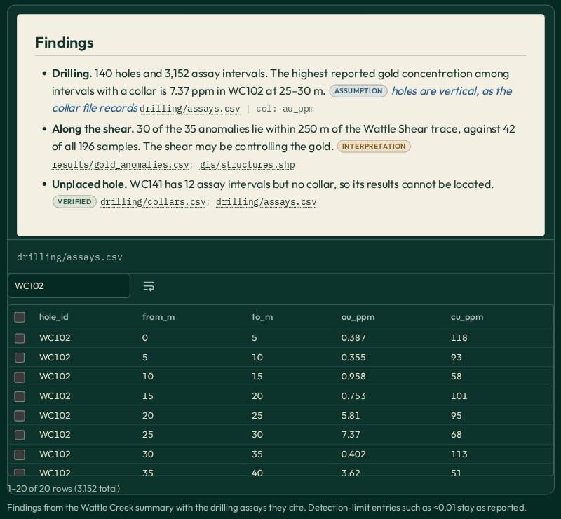
As a geology AI agent, its handling of data is specific. It uses length-weighted means for drillhole intervals and treats below-detection assays as half the detection limit, two conventions a geologist can check and disagree with.
The research harness is open source on GitHub.
Eigenform’s own evidence so far includes a blind test in Western Australia. In the Coe Fairbairn case study, Eigenform gave its AI models only exploration data from before a 2021 rare earth discovery and asked where such deposits might lie. They pointed to the area where rare earths were later found. The case study presents the answer as a testable hypothesis that still needs field validation, not as proof, and this article reads it the same way.
AI mining software: what to look for before you buy
If you are comparing AI mining software, check the following before looking at a demonstration.
- Data formats. The tool should read the formats your team already holds. As a reference point, the GeoCluster page lists CSV, TSV, XLS, XLSX, PDF, Markdown, images, Shapefile, GeoJSON, GeoPackage, MapInfo TAB, GeoTIFF, ER Mapper and NumPy volumes.
- Verification. Ask how you can trace a result to its source data, and whether you can export the steps behind it.
- Fit with existing software. The tool should work next to your modelling and database software, not replace it. A shortlist of options is in the best AI tools for geology guide.
- Map handling. If your data starts as scanned maps, ask how positions are set. Eigenform’s guide to georeferencing a scanned map from coordinates shows what that step involves.
Vendor demonstrations are demonstrations
Treat vendor material as what it is. A vendor tool is built for specific workflows, and a vendor demonstration shows what the tool can do, not how it performs on your data. Ask for a trial on a dataset you already understand, so you can judge the output against what you know.
How AI mining fits with your existing geology software
AI tools sit alongside modelling and database software and do not replace them. The usual order is simple:
- Database. Validated collar, survey and assay records stay in the system that holds them.
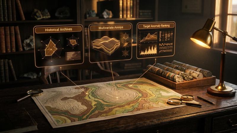
- AI analysis. The AI tool reads those records, with any maps, reports and survey grids, and looks for patterns or ranks areas.
- Model. The geologist takes the results that survive checking into modelling software to build and test the geological interpretation.
The AusIMM article makes a similar point about modelling: the AI model acts as an independent benchmark that either reinforces confidence in a conventional result or points to zones worth another look. In every step, the geologist decides what moves forward.
FAQs
What is AI mining?
AI mining, as used in this article, means artificial intelligence applied to mineral exploration and geology. It covers software that reads reports and maps, finds patterns in geochemical and geophysical data, and ranks places to investigate. The phrase also covers mine operations AI and cryptocurrency mining.
Is AI mining the same as cryptocurrency mining?
No. Cryptocurrency mining is computing work that validates digital currency transactions and has nothing to do with rock or minerals. AI mining in geology means using artificial intelligence to support mineral exploration, such as reading old reports, finding patterns in assays and survey data, and ranking targets for a geologist to review.
How is AI used in geology and mineral exploration?
AI is used to read old reports and maps, support core logging, find patterns in geochemical and geophysical data, suggest targets, and draft reports. In each case it speeds up data work, and a geologist still checks the output. Mining Technology quotes Micromine on modelling, core scanning and target identification.
Can AI replace geologists?
No. Mining Technology quotes a Micromine product manager who says good geologists are still needed to verify AI predictions, and a US Geological Survey geologist who expects no AI geologist to do all the work. AI takes over repetitive data tasks, while interpretation and drilling decisions stay with people.
Can AI find mineral deposits?
AI can suggest where to look by finding patterns in existing data, but it cannot confirm a deposit. Only sampling and drilling do that. A 2024 Earth-Science Reviews paper notes limited testing in practical deployment, so treat AI targets as hypotheses that a geologist must check before any money is spent.
What data does AI need to work in exploration?
It needs the data a geologist would use: assays, drillhole records, geophysics grids, maps and reports, in readable digital form. Quality matters more than volume, because poor data produces confident but wrong results. Check units, below-detection values and coordinate systems before an AI tool sees them.
How do I know if an AI result can be trusted?
Trace it. You should be able to follow the result back to the measurements that produced it, see which parts are data and which are interpretation, and reproduce the steps. If a tool gives you a score with no way to inspect the inputs, treat it as a black box and verify independently.
Try It With Geocluster
If you want to see traceable results on your own data, GeoCluster runs in the browser with no installation, and the Geocluster tools page lists what is available.
For evidence of this kind of work on a real project, the case studies show where AI has been applied to geological data.