Key Takeaways
- The task today: Geologists search for the best exploration software to manage mapping, drilling and mineral discovery, while AI tools like GeoCluster and open-source packages help them find targets faster.
- Exploration software is a stack of tools rather than one program: Finding minerals requires separate software packages for spotting map targets, testing rock chemistry, storing drill records and drawing 3D underground models.
- Choose software based on your exploration stage: Teams starting on regional land need mapping and data analysis, while teams drilling underground need secure databases and 3D computer models.
- AI platforms accelerate work but still require human verification: Computer models highlight promising areas on maps, but geologists must still check physical rock core and original laboratory test sheets before drilling.
TL;DR
The best exploration software combines target generation, chemical analysis, database governance and 3D geological modelling into a connected workflow. Rather than relying on a single program, modern mineral teams use specialized software at each stage: from AI prospectivity tools that spot prospective ground to modelling software that maps deposits underground. This practical guide compares leading software tools across every exploration stage to help teams choose the right stack.
What is mineral exploration software?
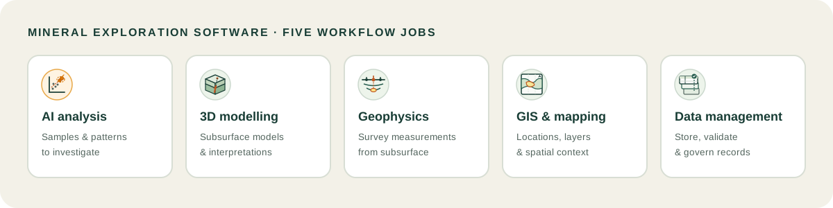
Mineral exploration software is a specialized suite of digital tools designed to capture, validate, process, and model geological, geophysical, and geochemical data to discover economic mineral deposits. Specifically, evaluating mining exploration software requires understanding five primary jobs: regional target generation, exploratory data analysis, geophysical cartography, drillhole database management, and 3D subsurface modelling.
This post focuses exclusively on solid mineral exploration, covering precious metals, critical minerals, and base metal deposits, rather than petroleum or gas exploration. While oil and gas exploration tools emphasize seismic reflection processing and continuous basin fluid dynamics, mineral exploration platforms focus on complex structural faulting, multi-element geochemistry, and hard-rock drillhole intervals.
Determining the best exploration software for a given mineral deposit depends on balancing specialized analytical precision against broad workflow integration. Consequently, modern teams configure modular toolsets rather than relying on a single monolithic program. In addition, software stacks must scale smoothly from early generative exploration to active drilling.
Understanding where individual tools fit requires looking at the broader ecosystem of geology software that modern mining companies deploy across exploration life cycles.
Best exploration software for mineral teams, compared by workflow stage
Mineral exploration programmes do not rely on a single software package. Instead, exploration managers assemble a curated software stack where specialized applications handle distinct workflow stages. In this comparison, tools within the same category (such as Leapfrog Geo, Micromine Origin, Maptek Vulcan, and Surpac) serve as direct alternatives, whereas tools across categories complement one another in a complete pipeline. The following table evaluates 12 leading exploration software tools across workflow stages, data capabilities, and ideal user profiles based on documented features checked in 2026.
| Software | Workflow Stage | Best For | Key Data Handled | Deployment | Target Team |
|---|---|---|---|---|---|
| VRIFY | Target Generation | AI prospectivity mapping | Regional GIS, Historical deposits | Cloud SaaS | Regional exploration managers |
| GeoCluster | AI Data Analysis | Tabular AI investigation | Assays, Grids, Geological tables | Browser-based | Exploration geologists evaluating anomalies |
| ioGAS (Imdex) | Geochemical Analysis | Exploratory multivariate QC | Whole-rock assays, pXRF, Mineralogy | Desktop Windows | Project geochemists |
| Leapfrog Geo | 3D Modelling | Implicit structural modelling | Drillholes, Point clouds, Meshes | Desktop client | Resource estimation teams |
| Micromine Origin | 3D Modelling | Integrated exploration modelling | Drillholes, Wireframes, Geostatistics | Desktop Windows | Mid-tier mining exploration teams |
| Maptek Vulcan | 3D Modelling | Complex structural block modelling | Mine grids, Drillholes, Block models | Desktop Windows | Corporate mining operations |
| GEOVIA Surpac | 3D Modelling | Resource evaluation and planning | Drillholes, Underground surveys | Desktop Windows | Mine-site production geologists |
| Oasis montaj | Geophysics | Airborne potential-field filtering | Magnetics, Radiometrics, Gravity | Desktop Windows | Specialist exploration geophysicists |
| Target (Seequent) | Geophysics and Mapping | Field drillhole mapping | Collars, Downhole surveys, Assays | Desktop Windows | Early-stage drilling teams |
| acQuire GIM Suite | Data Management | Enterprise sample governance | Laboratory certificates, QA/QC batches | Enterprise client-server | Major mining corporations |
| MX Deposit | Data Management | Cloud-native drillhole logging | Mobile field logs, Core photography | Cloud SaaS | Junior explorers and field camps |
| CorePlan | Data Management | Operations and drilling tracking | Rig plods, Core progress, Invoices | Cloud SaaS | Drilling operations managers |
AI platforms for mineral exploration
1. VRIFY
VRIFY provides artificial intelligence prospectivity mapping and interactive 3D visualization. Specifically, its DORA engine uses deep learning to generate predictive mineral prospectivity maps by synthesizing regional geochemical surveys, geophysical grids, and known deposit locations. Consequently, exploration teams use VRIFY to provide a systematic, data-driven ranking of regional targets that complements geological review, though model outputs remain dependent on input data coverage and training assumptions.
2. GeoCluster
GeoCluster is an open-access AI investigation tool developed for geological datasets, available through a hosted browser interface and an open-source research harness, with custom enterprise deployment options. Running directly inside a web browser without requiring local software installation or API credentials, GeoCluster ingests diverse files including CSV tables, shapefiles, GeoTIFFs, and historical PDF reports.
To see how the underlying agent coordinates multi-step investigations, developers can inspect the open-source geocluster research harness repository on GitHub.
In a typical workflow, a user uploads tabular assay data and spatial tenement boundaries. The agent executes geology data analysis software routines, calculating length-weighted assay averages and treating censored values below detection limits as half the limit during mathematical clustering.
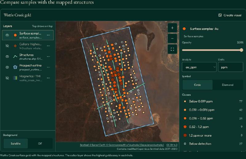
Geologists utilize its multivariate geochemical clustering and anomaly tools to run automated pathfinder searches across tenements, linking every generated anomaly score back to its primary sample coordinates and laboratory certificate ID.
To examine how automated machine learning accelerates targeting, geologists can review our detailed technical guide on AI in mineral exploration and its operational checks.
3. ioGAS (Imdex)
ioGAS is widely recognized as a benchmark for geochemical exploratory data analysis. The software provides an extensive library of specialized classification diagrams, immobile trace-element ratios, and automated outlier detection routines. Consequently, geologists use ioGAS to separate true hydrothermal alteration halos from background host rock lithology, exporting validated domains directly into downstream 3D modeling packages.
3D geological modelling software for exploration
4. Leapfrog Geo (Seequent)
Leapfrog Geo is widely recognized for introducing implicit geological modelling using Radial Basis Functions (RBF). Instead of manually drawing wireframe polylines section by section, geologists define stratigraphic sequences and structural rules, allowing Leapfrog to interpolate 3D volumes and vein structures directly from drillhole pierce points. Furthermore, Leapfrog connects with Seequent Central to maintain revision control across distributed modelling teams.
5. Micromine Origin
Micromine Origin provides an integrated exploration modelling environment combining drillhole validation, structural mapping, and geostatistical estimation. Specifically, it excels at managing large spatial databases, allowing exploration teams to model complex folded stratigraphy and wireframe mineralized envelopes without switching between disparate applications.
6. Maptek Vulcan
Maptek Vulcan is an enterprise modelling system widely utilized across large-scale exploration and mining operations. Vulcan offers advanced geostatistical tools, block modelling routines, and structural analysis capabilities. Consequently, it handles vast datasets spanning hundreds of thousands of drillhole metres, serving mature brownfield programmes advancing toward feasibility studies.
7. GEOVIA Surpac (Dassault Systèmes)
GEOVIA Surpac is an established mining software package supporting resource delineation and mine planning. For exploration teams, Surpac provides drillhole database tools, section plotting, surface generation, and block modelling. Therefore, it provides an operational bridge between initial exploration drilling and long-term mine engineering.
Geophysics and field mapping software
8. Oasis montaj (Seequent)
Oasis montaj is widely adopted across the mining industry for processing and visualizing airborne and ground geophysical surveys. Exploration geophysicists use Oasis montaj to filter potential-field data, apply Fast Fourier Transforms (FFT) to aeromagnetic surveys, and calculate 3D Euler deconvolution.
Furthermore, geologists evaluate subsurface fault networks and basement depth using dedicated geophysics software that isolates structural lineaments associated with major mineral systems.
9. Target (Seequent)
Specifically, Target is a desktop mapping and drillhole visualization tool tailored for field geologists. It simplifies the generation of drill plan maps, cross-sections, and downhole strip logs. By providing built-in QA/QC scatter plots and 3D viewing, Target allows drilling teams to verify collar coordinates and assay trends quickly at the field camp.
Exploration data management software
10. acQuire GIM Suite
acQuire GIM Suite provides enterprise sample governance across major mining corporations. The platform centrally manages drillhole collars, assay certificates, downhole surveys, and quality control batches. It enforces strict relational integrity rules, preventing invalid coordinates or unverified laboratory batches from entering corporate resource models.
11. MX Deposit (Seequent)
MX Deposit is a modern cloud-native exploration database platform. It allows field technicians and geologists to log drill core and capture field samples directly on mobile devices, even in offline environments. Data synchronizes automatically to the cloud once connectivity is restored, replacing manual spreadsheet handoffs with structured digital logging.
Therefore, managing sample governance effectively requires dedicated geological data management platforms that audit every record modification throughout active drilling campaigns.
12. CorePlan
This cloud-native operations management platform is designed to track diamond drilling campaigns. Specifically, the system manages contractor plods, tracks rig progress against planned metres, reconciles invoices against contract rates, and provides real-time visibility into exploration drilling costs.
How to choose the best exploration software for your project
Choosing the best exploration software requires identifying your project’s specific maturity level and technical constraints. Selecting tools that mismatch your workflow stage leads to wasted software licensing capital and operational bottlenecks.
When evaluating potential candidates, teams should assess four primary decision criteria:
- Workflow stage alignment: Early-stage greenfield explorers need GIS overlays, geophysical processing, and geochemical clustering tools. In contrast, advanced resource delineation requires high-end implicit modellers, block modelling engines, and certified relational databases.
- Data format interoperability: Choose platforms that read open tabular, spatial, and voxel formats. Software that forces proprietary lock-in prevents geologists from combining geophysical grids with geochemical anomalies.
- Traceability and auditability: Ensure every analytical output maintains a clear provenance record back to original sample IDs and laboratory certificates.
- Deployment architecture: Consider connectivity in remote field camps. Cloud-native or lightweight browser tools reduce local hardware demands and eliminate license server configuration issues.
To implement automated investigation workflows, exploration managers can explore how a geology AI agent orchestrates multiple analytical tools within a unified research harness.
Best mineral exploration software for each type of team
Operational requirements differ substantially depending on team size and operational scope. The following scenarios highlight the best mineral exploration software combinations for common industry profiles:
- The Junior Exploration Startup: Early-stage explorers managing tight budgets should combine QGIS for regional spatial cartography, GeoCluster for browser-based AI geochemical clustering, and MX Deposit for cloud drillhole logging. This stack minimizes upfront software capital expenditures while maintaining rigorous data governance.
- The Consulting Structural Geologist: Independent geological consultants require versatile tools capable of importing diverse client datasets. Combining Leapfrog Geo for 3D implicit modeling with ioGAS for geochemical alteration analysis provides the analytical breadth needed for contract targeting.
- The Brownfield Mine-Site Exploration Team: Operating near active mine infrastructure requires deep integration between exploration databases and mine planning software. Deploying acQuire GIM Suite alongside Micromine Origin or Maptek Vulcan ensures that infill drilling data flows directly into official resource block models.
- The Team Managing Historical Archives: Exploring brownfield ground with decades of legacy reports requires dedicated digitisation pipelines. Teams use automated tools for digitising old geological maps to recover forgotten spatial contacts from paper archives.
Furthermore, teams handling extensive historical exploration reports routinely deploy PDF table extraction to convert locked drillhole tables into clean digital databases.
How AI in mineral exploration and traditional software work together
Modern exploration platforms do not replace established software packages; they operate alongside them in an integrated, multi-stage workflow:
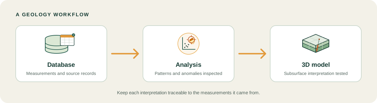
In this connected architecture, database software governs primary empirical records. AI platforms and geochemical analysis software ingest those validated records to generate ranked exploration targets without altering raw laboratory values. Finally, validated target contacts import into 3D modelling packages to construct resource wireframes, demonstrating how the best exploration software connects every stage from discovery to definition. Importantly, this workflow is iterative: structural interpretations in 3D models often reveal new geological domains, prompting teams to re-analyze geochemical anomalies and refine drill targets.
To understand how emerging artificial intelligence tools integrate into daily geology workflows, teams can review our practical guide on the best AI tools for geology for modern geoscientists.
Geologists can also inspect an interactive 3D voxel model demo to see how multi-scale drillhole and geochemical data combine into navigable three-dimensional volumes.
Spatial boundary validation in Stratigraphic Amenity
The fundamental challenge in connecting disparate exploration software tools across the mineral discovery stack is maintaining coordinate integrity. Whether integrating regional airborne geophysics with localized drillhole collars or querying external mineral deposit databases, spatial data must be strictly validated. This architectural discipline is implemented in Stratigraphic Amenity, an open-source MCP server that gives AI agents tools for geological investigation.
When an exploration pipeline exchanges spatial data between mapping tools and geochemical clustering agents, coordinate reference system (CRS) discrepancies can displace anomalies by hundreds of metres. Stratigraphic Amenity enforces deterministic coordinate resolution with CRSResolutionError exceptions in src/stratigraphic_amenity/georef/crs.py:42-62:
    if isinstance(spec, bool):  # bool is an int subclass; reject explicitly.
        raise CRSResolutionError(f"Invalid CRS specification: {spec!r}")
    if isinstance(spec, int):
        return f"EPSG:{spec}"
    if not isinstance(spec, str) or not spec.strip():
        raise CRSResolutionError(f"Invalid CRS specification: {spec!r}")

    text = spec.strip().lower()

    epsg_match = re.fullmatch(r"epsg:\s*(\d+)", text)
    if epsg_match:
        return f"EPSG:{int(epsg_match.group(1))}"

    if "utm" in text:
        zone_match = re.search(r"zone\s*0*(\d{1,2})", text)
        if not zone_match:
            raise CRSResolutionError(f"Could not find a UTM zone in {spec!r}")
        zone = int(zone_match.group(1))
        if not 1 <= zone <= 60:
            raise CRSResolutionError(f"UTM zone {zone} out of range (1-60) in {spec!r}")
In addition, spatial queries to external geological databases require bounding box validation to prevent malformed coordinates from triggering silent query failures. In src/stratigraphic_amenity/knowledge/bounds.py:24-40, the Bounds dataclass validates geographic bounds in decimal degrees before knowledge retrieval begins:
@dataclass
class Bounds:
    min_lon: float
    min_lat: float
    max_lon: float
    max_lat: float
    crs: str = "EPSG:4326"

    def __post_init__(self) -> None:
        try:
            self.min_lon = float(self.min_lon)
            self.min_lat = float(self.min_lat)
            self.max_lon = float(self.max_lon)
            self.max_lat = float(self.max_lat)
        except (TypeError, ValueError) as exc:
            raise InvalidBoundsError("Bounds values must be decimal degree numbers.") from exc
By enforcing strict coordinate resolution and bounding constraints at the code level, Stratigraphic Amenity ensures that automated exploration agents can query multi-stage datasets without corrupting spatial coordinates.
FAQs
What software is considered the best for mineral exploration?
The best software depends on workflow stage. In our 2026 evaluation, Leapfrog Geo is widely recognized for 3D implicit structural modelling, ioGAS leads geochemical analysis, Oasis montaj leads geophysics, acQuire leads enterprise data management, and GeoCluster provides browser-based AI target investigation.
What software do exploration geologists use?
Exploration geologists use an interconnected stack of software: GIS packages like QGIS and ArcGIS Pro for field mapping, geochemical platforms like ioGAS for alteration analysis, 3D modelling packages like Leapfrog Geo for wireframing, and cloud databases like MX Deposit for mobile drill core logging.
Is there free exploration software?
Yes, QGIS is a free, open-source geographic information system widely used for geological mapping and spatial analysis. Additionally, open-source python libraries like GemPy and PyGIMLi handle 3D implicit modelling and geophysical inversions, while GeoCluster provides open-access browser investigation tools.
What is the difference between exploration software and mine planning software?
Exploration software focuses on early-stage target generation, probabilistic anomaly detection, and 3D structural interpretation from sparse data. In contrast, mine planning software prioritizes deterministic engineering calculations, pit optimization, blast scheduling, and grade control within active mining operations.
Can AI replace exploration software?
No, AI does not replace core exploration software. Instead, AI platforms operate as analytical accelerators that synthesize complex geochemical and geophysical datasets to highlight prospective drill targets, while geologists continue using 3D modellers and databases to validate targets and estimate resources.
What data do I need before using exploration software?
Before using exploration software, you typically need spatial collar coordinates, downhole deviation surveys, laboratory assay certificates, geological lithology logs, and georeferenced surface mapping or geophysical grids. Clean, structured datasets ensure accurate modelling results.
Is oil and gas exploration software the same as mineral exploration software?
No, petroleum exploration software focuses heavily on continuous sedimentary basin fluid dynamics and large-scale seismic reflection processing. Mineral exploration software focuses on hard-rock structural geology, complex faulting, multi-element geochemical alteration halos, and discrete diamond drillhole intervals.
Try It With Geocluster
Open GeoCluster to investigate geological exploration data directly in your web browser with an AI agent, without requiring software installation or server configuration.
To see documented results from retrospective field investigations, explore our AI mineral exploration case studies detailing target validation from historical exploration archives.