Key Takeaways
- Geology AI is software that helps geologists read maps, reports and data. Some of it works as a helper program that an AI chat assistant can call on, much like an assistant asking a specialist colleague for help.
- That helper program has several parts, and some may not be set up on your computer yet. So before the AI assistant asks it to read a geologic map (a map showing which rocks lie where), it should first ask: “What can you do right now?”
- The answer lists each job, marks it ready or not ready, and says what is missing. Even “ready” only means the parts are in place. It does not promise the program has information about your area.
TL;DR
Before an AI assistant asks a geology map program to do a job, it should check which parts of that program actually work. It is like checking which machines in a workshop are switched on before starting. This post explains that check and how to read its answer.
What Is geomap_list_capabilities?
Stratigraphic Amenity is Eigenform’s open-source (MIT) MCP server for scanned geologic maps. It runs locally next to an AI client and exposes ten tools: registering a map, detecting the legend and map frame, georeferencing, and querying geological knowledge for an area.
Several of those parts are optional installs. The map detector needs model weights and a managed runtime. The rock-type lookups need a knowledge base file, and the land-cover provider needs a Google Earth Engine project set up. So a server may be fully, partly or barely installed, and an agent cannot tell which from the tool list alone.
geomap_list_capabilities answers that question. It takes no arguments, changes nothing, and is safe to call at the start of every session.
How Does a Geology AI Agent Read the Capability Report?
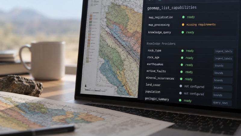
The report covers seven capabilities, such as map_registration, map_processing and knowledge_query, plus ten knowledge providers. Three parts of it matter most.
Registered, installed, configured, ready
Each entry has the same four flags. registered means the server knows the feature exists. installed means the Python packages or runtime it needs are present. configured means its files or settings exist, such as detector weights or an Earth Engine project. ready is true only when the feature is installed, configured and has no outstanding requirements.
On a light install, the summary reads: “1 of 10 knowledge providers are ready.” It then lists map_processing with seven outstanding requirements, including the runtime and both detector weight files.
supported_requests: what each provider accepts
Provider records add a supported_requests field. Rock type and rock age accept legend_labels. Earthquakes, active faults, mineral occurrences, land cover and population accept bounds, a bounding box. The three semantic knowledge providers accept query_text.
A ready provider still fails if it gets the wrong kind of request. The aggregate knowledge_query capability counts as ready when at least one provider can serve a request. It also reports ready_provider_count and registered_provider_count, so the agent can see how partial that support is.
missing_requirements: what a geology AI agent does next
missing_requirements reads as a set of instructions. When map processing is not ready, the summary says: “Do not call geomap_process_image until map_processing is ready.” It then points to geomap_prepare_detectors, or asks the server operator to step in when that tool cannot run.
The detector preparation tool downloads about 200 MiB and writes to disk, so the agent should ask the user before calling it. It should never install the detector from its own shell: that is a different environment, and the files land in the wrong place.
What a Ready Flag Does Not Tell a Geology AI Agent
Readiness checks that the pieces exist. It does not open the earthquake or fault mirror files, test a network connection, or check that a region is covered. A ready provider can still return nothing for an area it has no data for.
A geology AI agent should treat an empty result as “no records found here”, not “nothing exists here”. The same rule shaped our MCP tool design for real agents: results carry warnings, knowledge records carry provenance, and the agent has to read both before making a factual claim.
The report also lists the server’s limits without exposing local paths. Allowed folders appear only as labels such as root_1, a source map can be up to 200 MiB, and a resource read up to 50 MiB. Those limits matter for the next step, loading a scanned geologic map.
FAQs
What does geomap_list_capabilities tell a geology AI agent?
It returns schema versions, which optional packages are installed, detector status, readiness for each capability and knowledge provider, labels for the allowed folders, and byte limits. Every entry shows whether it is registered, installed, configured and ready, and lists anything still missing, so an agent can plan before calling other tools.
What is the difference between installed and ready?
Installed means the code a feature needs is present. Ready also requires its files and settings, such as detector weights or a knowledge base, and no outstanding requirements. A feature can be installed but not ready, for example when the detector runtime exists but nobody has downloaded its two model weight files yet.
Why can knowledge_query be ready when most providers are not?
The aggregate capability is ready when at least one knowledge provider can serve a request. It does not mean every provider works. Check ready_provider_count, each provider’s own ready flag and its supported_requests before choosing which providers to query.
Should a geology AI agent install missing detectors itself?
No. It should call geomap_prepare_detectors only after the user agrees, because the tool downloads about 200 MiB and writes to disk. Installing from the agent’s own shell puts files in a different environment from the server’s, so the server still reports the detector as missing afterwards.
Try It With Geocluster
Stratigraphic Amenity is one of the Geocluster tools, MCP servers that let AI agents work with geology data and maps.
It grew out of our Geological Map Processing Suite, which explains how it builds on Microsoft’s PEACE research to turn scanned maps into evidence an agent can cite.