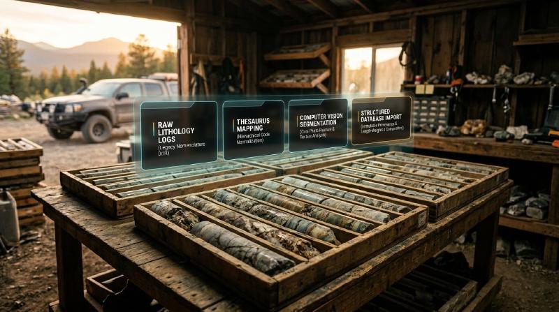
Core logging software helps exploration teams capture and harmonize geological descriptions from drill cores across multi-year exploration programs.
TL;DR
Looking to resolve contradictory rock descriptions across historic drilling campaigns? Core logging software and automated standardization workflows convert subjective geologist notes into unified, structured exploration datasets while preserving original evidence anchors. Consequently, this practical guide explains why manual lithology logs diverge, how thesaurus matching normalizes historical archives, where machine learning assists, and how to verify automated classifications against original core boxes.
Key Takeaways
- Core logging software standardizes descriptive rock records into structured digital databases. The open-source GeoCluster research harness provides automated tools for parsing tabular drillhole exports and preserving evidence links back to original core photography.
- Manual drill core descriptions vary across geologists, companies, and exploration eras. Personal observational habits, local mine terminology, and unconstrained free-text fields frequently produce fragmented databases across adjacent campaigns.
- Automated normalization requires hierarchical vocabulary mapping rather than blind search. Open-source tools map legacy lithology variants into standardized parent classifications using semantic thesauri and fuzzy string algorithms.
- Software cannot repair erroneous or fabricated legacy observations. Automated matching improves semantic consistency across campaigns, but verifying geological truth still requires checking original core trays and quantitative assay intervals.
What Does Standardization Mean in Core Logging?
In exploration data management, teams often use terms like standardize, normalize, harmonize, and classify interchangeably. However, these terms represent fundamentally distinct data engineering and geological operations.
Clarifying these operational boundaries ensures that teams do not confuse lexical code matching with verified geological interpretations.
| Standardization Operation | Specific Data Action | Example Transformation | Geological Verification Status |
|---|---|---|---|
| Code Mapping | Translates legacy abbreviations into a controlled vocabulary | BAS mapped to Basalt | Reconciles terminology only; does not verify rock type |
| Attribute Extraction | Splits compound notes into structured relational columns | Extracts alteration and texture from comments | Parses descriptive text without confirming intensity |
| Stratigraphic Assignment | Links lithological intervals to formal regional formations | Assigns interval to regional greenstone belt unit | Requires external map and structural validation |
| Image-Based Prediction | Infers rock domains and RQD from core photography | CNN segments broken core into 10 cm intact pieces | Evaluates surface optical properties; misses hardness |
| Geological Validation | Expert inspection verifying observations against physical rock | Geologist re-logs core box or cross-checks assays | Confirms physical ground truth and contact boundaries |
Automated core logging software standardizes terminology and database structure across disparate exploration campaigns. However, validating whether the original rock identification was physically accurate remains an interpretive geological task.
Why Are Manual Lithology Logging Records Inconsistent?
In exploration drilling, lithology logging represents the manual recording of rock types, alteration assemblages, textures, and structures observed along drill core intervals. Because different geologists log core across decades of exploration campaigns, these descriptive records inevitably suffer from observational inconsistencies.
Subjective terminology represents the primary driver of database fragmentation. For example, in regional drillhole compilations across Western Australia (GSWA WAMEX database), researchers noted that terms such as “laterite,” “duricrust,” “saprolite,” and “saprock” were applied inconsistently to equivalent regolith horizons across adjacent campaigns.
Furthermore, exploration companies frequently alter internal coding standards during corporate reorganizations. Consequently, a single geological unit might be logged as BIF in 1985, Fe_SND in 1998, and JSP_MAG in 2012, fracturing geological continuity in 3D block models.
| Source of Inconsistency | Mechanism of Database Distortion | Operational Impact on Exploration |
|---|---|---|
| Geologist Subjectivity | Varying visual estimation of grain size, mineral abundance, and rock color | Contradictory lithology boundaries between adjacent drillholes |
| Terminology Drift | Evolving stratigraphic nomenclature across multi-decade campaigns | Same rock formation assigned multiple disconnected database codes |
| Free-Text Overuse | Critical lithological qualifications buried in unconstrained comment fields | Automated filtering misses hidden mineralized intervals |
| Variable Log Resolution | Intervals logged at 10-centimeter scale versus 5-meter composite intervals | Complex lithological boundaries smoothed or over-split |
| Differing Company Standards | Joint venture partners using incompatible stratigraphic codes | Inability to merge regional drillhole databases without manual translation |
Note that the corporate code drift in the table above illustrates common logging pitfalls. In contrast, regolith nomenclature drift in Western Australia reflects documented historical survey findings.
What Does Automated Core Logging Software Do?
Modern core logging software serves two fundamentally distinct functions in exploration workflows: data capture and post-collection standardization. Distinguishing these roles prevents teams from confusing data entry systems with automated classification engines.
Real-Time Core Logging Software Capture Systems
First, digital capture systems replace traditional paper logging sheets with structured field tablets. These tools enforce validation rules at the point of capture, requiring geologists to select lithology names from standardized dropdown menus and preventing overlapping depth intervals.
Post-Collection Core Logging Software Standardization
Second, post-collection standardization engines process legacy historical logs. These systems utilize natural language processing, semantic thesauri, and machine learning to map thousands of unstructured historical descriptions into a unified stratigraphic framework.
| Core Logging Software Type | Primary Capabilities | Typical Input Data | Target Users |
|---|---|---|---|
| Field Capture Systems | Real-time interval validation, dropdown taxonomies, collar QA/QC checks | Direct manual input on rugged tablets, barcode core scans | Mine site and field exploration geologists |
| Thesaurus Standardization Engines | Fuzzy string matching, hierarchical lithology mapping, dictionary reconciliation | Unstructured CSV/database tables, legacy text exports | Exploration database managers, resource estimators |
| Computer Vision Logging Platforms | Automated rock texture segmentation, fracture counting, RQD calculation | High-resolution wet/dry RGB core tray photography | Geotechnical engineers, exploration project teams |
| Downhole Multi-Sensor Ingestion Tools | Merging hyperspectral scans, pXRF assays, and wireline geophysics | Continuous downhole point spectra, physical property logs | Geometallurgists, advanced targeting specialists |
Teams planning regional data integration should explore modern geological data management software to evaluate how relational schemas store standardized lithology hierarchies alongside raw historical entries.
How to Standardise Lithology Logs Into One Dataset
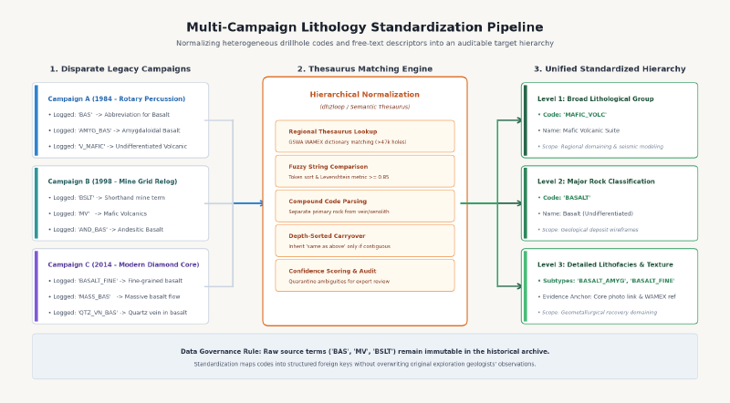
Standardizing disparate legacy logs into a single coherent database requires a systematic data engineering workflow. Rather than manually editing millions of database rows, teams apply rule-based algorithms supported by geological domain dictionaries.
Five-Step Lithology Standardization Pipeline
A leading peer-reviewed methodology is demonstrated by dh2loop, an open-source Python library developed for automated 3D geological modeling (Joshi et al., 2021, Geoscientific Model Development). Specifically, the standardization pipeline follows five discrete steps:
- Step 1: Extract and clean relational drillhole tables. Extract collar coordinates, downhole deviation surveys, and lithology interval tables from source databases, ensuring primary keys match.
- Step 2: Construct the regional lithology thesaurus. Compile a comprehensive reference dictionary linking formal stratigraphic formations, igneous rock types, and regolith terms to unique standardized classification codes.
- Step 3: Apply fuzzy string matching to categorical codes. Match legacy code strings against the dictionary using Levenshtein distance metrics and token sort algorithms with defined acceptance thresholds (such as 0.85 similarity).
- Step 4: Map codes into a three-level hierarchical taxonomy. Group matched terms into a nested hierarchy (for example: Level 1 “Mafic Volcanic”, Level 2 “Basalt”, Level 3 “Amygdaloidal Basalt”).
- Step 5: Review and quarantine unmatched records. Export all intervals that fail confidence thresholds or yield ambiguous multiple candidates to a quarantine spreadsheet for manual expert review.
In benchmark evaluations on over 47,000 historical drillholes from the Geological Survey of Western Australia (GSWA) WAMEX database, dh2loop achieved an 86% automated matching rate on primary lithology codes. In this evaluation, the matching rate measures the proportion of unique legacy code strings successfully mapped to the reference thesaurus without manual intervention.
End-to-End Worked Mapping Example
Consequently, teams can trace how raw inputs transform into verified classifications. The table below illustrates an end-to-end worked record passing through this automated standardization workflow.
| Processing Stage | System Field | Example Transformation Value |
|---|---|---|
| Source Identification | Drillhole ID & Interval | DDH-001, depth interval 45.0 to 48.2 m (Illustrative drillhole) |
| Raw Input Data | Logged Code & Comment | Code: QTZ; Comment: “Quartz vein with 60% basalt xenoliths” |
| Evidence Provenance | Archival Document Anchor | Assessment Report WAMEX A12345, Page 14, Table Row 8 |
| Thesaurus Candidates | Fuzzy String Candidates | 1. Quartz Vein (Token score: 1.00); 2. Basalt (Token score: 0.88) |
| Classification Decision | Automated System Flag | Quarantined: ambiguous multi-lithology mixture |
| Decision Rationale | Rule Explanation | Compound interval contains significant host xenoliths; single code assignment loses rock volume |
| Output Database Record | Standardized Classifications | Primary: Quartz Vein; Secondary: Basalt (60%); Status: Geologist Approved |
| Audit Trail Record | Verification Metadata | Reviewer: M. Joedhitya; Action: Accepted hybrid mapping; Version: 1.2 |
Furthermore, teams processing historical exploration filings can combine this workflow with automated pdf table extraction to extract legacy interval tables from archived assessment reports directly into database schemas.
How to Handle Free-Text Comments
While primary code fields yield high automated matching rates, free-text comment fields present significant challenges in drill core logging. Historically, logging geologists used comment fields to qualify ambiguous rocks, record alteration intensity, or contradict their own primary lithology code.
The Free-Text Parsing Challenge
In the dh2loop GSWA WAMEX benchmark study, while primary codes achieved an 86% match, only 16% (7,870 of 47,823) of free-text comments matched the regional thesaurus. The remaining 84% did not represent incorrect geology; rather, they contained idiosyncratic abbreviations, combined mineral descriptions, drillers’ mechanical notes, or ambiguous phrases that dictionary lookup alone could not parse.
Consequently, unstructured comments require specialized screening rules. The table below illustrates common comment ambiguities and their recommended processing rules.
| Interval (m) | Logged Code | Free-Text Comment (Illustrative Examples) | Automated System Action |
|---|---|---|---|
| 12.0 to 15.5 | SAPR | “Same as above but highly sheared” | Conditional context carryover evaluated |
| 45.0 to 48.2 | QTZ | “Quartz vein with 60% basalt xenoliths” | Intercalated mixture flag raised for review |
| 89.0 to 92.4 | BAS | “Actually fine-grained dolerite?” | Unresolved re-log query flagged for inspection |
| 110.0 to 114.0 | GRT | “Core lost: driller dropped rod” | Geotechnical core-loss flag recorded |
Conditional Rules for Comment Parsing
Therefore, automated standardization pipelines must establish explicit, conditional filtering rules to handle complex comment fields safely.
- Rule 1: Flag contradictory descriptions for manual verification. If the primary code says
ANDESITEbut the comment says “sheared quartz porphyry,” the system must preserve both fields and flag the conflict for geologist review. - Rule 2: Apply conditional context carryover. Comments stating “same as above” may inherit the preceding lithology only when records belong to the same drillhole, follow strict downhole depth order, and share a contiguous boundary with zero core loss.
- Rule 3: Separate lithology from secondary alteration. Phrases like “silicified hematitic basalt” must be parsed into lithology (
Basalt) and alteration types (Silicification,Hematite), leaving alteration intensity unassigned unless explicitly recorded. - Rule 4: Isolate drilling engineering artifacts. Descriptions identifying core loss, dropped rods, or cavity collapse must be routed to geotechnical flags while preserving the interval in the physical depth database.
AI Core Logging From Drill Core Images
The advent of high-resolution digital core photography has enabled automated core logging directly from imagery. Computer vision models, including convolutional neural networks (CNN) and vision transformers (ViT), analyze wet and dry core images to automate routine descriptive logging tasks.
Computer Vision Core Logging Capabilities
Commercial vendors like Datarock, along with research by SRK Consulting and GoldSpot Discoveries, demonstrate that machine learning models can segment core imagery into distinct categories. Specifically, these algorithms automate three repetitive measurement tasks:
- Rock Quality Designation (RQD) Calculation: Instance segmentation models detect individual core pieces and calculate RQD as the total length of sound core pieces ≥ 10 cm divided by run length, while distinguishing natural fractures from mechanical breaks.
- Textural and Grain Size Classification: Texture recognition networks classify rock fabrics into porphyritic, aphanitic, brecciated, or foliated domains based on surface spatial frequency.
- Coarse Lithological Domaining: Deep neural networks trained on thousands of labeled core trays predict broad lithological contacts based on color, texture, and reflectance characteristics.
Note that measuring true fracture orientations requires oriented core surveys with structural reference lines (measuring alpha and beta angles), which cannot be derived from unoriented flat box photos alone.
Physical Limits of Automated Core Logging Software
However, automated image logging faces physical limitations that require careful management. Specifically, computer vision models degrade rapidly when presented with historical photography captured under inconsistent lighting, through dirty core box lids, or on weathered core.
Furthermore, machine learning models evaluate only surface optical properties. They cannot assess rock hardness with a scratch pick, test carbonate reactions with hydrochloric acid, or inspect microscopic mineral cleavage, which remain essential for definitive lithology identification.
Exploration managers evaluating automated imaging tools should consult our review of AI in mineral exploration to understand where computer vision adds value and where it introduces false confidence.
How to Check an Automated Log Against the Original
Automating the standardization of legacy logs introduces the risk of silent classification errors. If a fuzzy matching algorithm incorrectly maps a sheared rhyolite as a barren sedimentary siltstone, downstream resource models and exploratory drill targeting will fail.
Four-Tier Audit Protocol Matrix
Therefore, exploration teams must enforce a multi-tier audit protocol before accepting automated logs into production databases.
| Verification Level | Inspection Methodology | Sample Size / Frequency | Acceptance Threshold & Rationale | Threshold Category |
|---|---|---|---|---|
| Statistical Code Audit | Compare pre- and post-standardization frequency distributions | 100% of transformed database records | Zero unmapped primary codes in production; unmapped records quarantined | Operational Recommendation |
| Random Physical Re-Logging | Senior geologist re-logs physical core trays against automated predictions | 5% to 10% of all drillholes | >90% concordance on Level 1 (rock group) and Level 2 (rock type) | Operational Heuristic |
| Assay Geochemistry Cross-Check | Validate lithology predictions against multi-element immobile trace ratios | All intervals with laboratory assays | Immobility ratios (Zr/TiO2, Nb/Y) match predicted volcanic group | Geochemical Standard |
| Source Provenance Verification | Verify every standardized interval links to original PDF page and log line | Random spot-check of 50 intervals | 100% traceable evidence anchors across transformed records | Data Governance Rule |
Evidence Anchors and Data Provenance
In addition, maintaining immutable source provenance represents the foundation of auditable geological data management. Consequently, every standardized database row must retain a direct pointer to the original logging geologist, the source report identifier, and the unedited raw text string.
For a detailed analysis of preserving provenance across historical archives, read our technical review on keeping evidence anchors in geology reports.
Core Logging Software Compared
Selecting appropriate core logging software requires matching organizational capabilities with exploration requirements. The table below compares leading academic and commercial platforms across core operational criteria and best-fit use cases.
| Platform / Tool | Tool Category & Primary Focus | Key Strengths | Critical Operational Limitation | Best-Fit Exploration Use Case |
|---|---|---|---|---|
| dh2loop | Open-source Python library; text thesaurus mapping | Automated dictionary matching; proven on 47,000 GSWA drillholes; hierarchical output | Requires Python scripting; text only; does not process core photos | Regional historical database harmonization |
| Datarock | Commercial SaaS platform; cloud computer vision | High-speed automated RQD, fracture logging, and texture domaining from core photos | Proprietary subscription; requires consistent high-resolution photography | Geotechnical logging and automated photo QA/QC |
| ALS GoldSpot / LithoLens | Commercial service; multi-sensor machine learning | Combines image segmentation with downhole geochemistry and spectral data | High service processing costs; proprietary algorithms; requires custom training | Complex brownfield deposit characterization |
| maxgeo LogChief | Commercial software; real-time field data capture | Enforces strict validation rules at entry; direct SQL database synchronization | Focused on manual data capture; no automated legacy standardization | Active field drilling and core shed data entry |
| GeoCluster Research Harness | Open-source research harness; tabular data ingestion | Auditable evidence links; length-weighted composites; automated table extraction | Does not provide automated lithology classification or computer vision | Open-source data preparation and audit pipelines |
Exploration teams preparing historical drill databases should follow our guide on how to verify historical drilling data before you use it to detect collar elevation shifts and interval overlaps before running standardization.
How GeoCluster Handles Lithology Data
The GeoCluster research harness provides exploration teams with open-source tools for processing, auditing, and querying multi-source drillhole databases. Rather than guessing lithological interpretations, GeoCluster enforces strict evidence traceability across all loaded datasets.
Specifically, the harness ingests drillhole datasets across industry-standard formats, including CSV, TSV, XLS, XLSX, and structured PDF assessment filings. When calculating composite grades across drillhole intervals, the platform automatically applies length-weighted averaging:
Furthermore, GeoCluster separates empirical measurements from geological interpretations. Assay numbers, collar coordinates, and downhole survey orientations are preserved as immutable factual records, while lithological classifications remain editable interpretive attributes linked to their source documents.
Teams evaluating geochemical associations across standardized lithological intervals can explore geochemical clustering tools to evaluate multi-element alteration signatures.
FAQs
What is core logging?
Core logging represents the systematic visual inspection and recorded description of cylindrical rock core recovered during diamond drilling campaigns. Field geologists document rock types, alteration assemblages, structural fabrics, mineralized veins, and geotechnical fracture frequencies along downhole depth intervals to establish the geological architecture of mineral deposits.
Why are lithology logs inconsistent?
Lithology logs become inconsistent because geologists apply personal visual estimation habits, regional stratigraphic nomenclature evolves over multi-decade exploration programs, and corporate logging codes change between operators. Furthermore, unconstrained free-text comment fields conceal critical rock qualifications that automated database filters cannot parse without structured domain dictionaries.
How do you standardise lithology logs?
To standardise lithology logs, teams extract relational collar, survey, and interval tables into structured database schemas. Next, engineers compile a hierarchical geological thesaurus and apply fuzzy string matching algorithms to map disparate legacy codes into controlled classifications while quarantining ambiguous descriptions for expert human review.
Can AI log drill core?
Computer vision algorithms can segment digital core photography, calculate geotechnical RQD, detect fracture frequencies, and classify broad textural domains. However, computer vision models cannot scratch minerals to assess hardness, test carbonate reactivity with acid, or substitute for expert geological logging in complexly altered or weathered rocks.
How accurate is automated core logging?
In published regional benchmarks like dh2loop, automated fuzzy string algorithms achieved an 86% match rate when mapping primary categorical codes to hierarchical dictionaries. In contrast, free-text comments yielded only a 16% dictionary match rate, demonstrating that unstructured notes require rigorous geologist auditing rather than unsupervised acceptance.
What is a lithology thesaurus?
A lithology thesaurus represents a controlled relational dictionary that organizes hundreds of synonymous rock descriptions, local field terms, and historical abbreviations into a hierarchical classification framework. By linking legacy variants to standardized parent and child categories, the thesaurus ensures that exploration models query uniform geological units.
Can software fix poor legacy logs?
Standardization software harmonizes descriptive nomenclature and repairs typographical errors, but it cannot fix fabricated observations, incorrect depth measurements, or misidentified minerals in legacy records. Confirming the geological truth of historical logs requires inspecting preserved physical core trays, examining high-resolution core photography, and cross-checking multi-element assay geochemistry.
Try It With Geocluster
The open-source GeoCluster research harness provides automated tools and agent workflows for reading exploration documents, desurveying drillholes, and structuring historical datasets.
Read our practical guide on how to verify historical drilling data before you use it to validate collars, surveys, and assays before updating your exploration database.