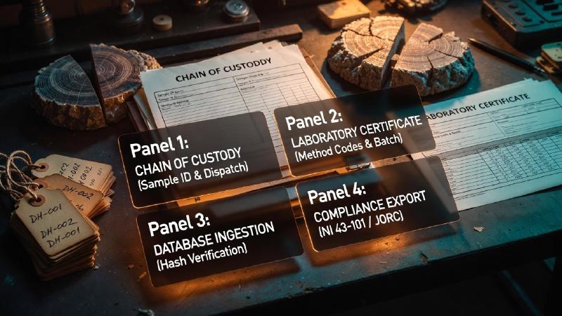
Key Takeaways
- The task today: Exploration geologists must establish data provenance for every drillhole interval and assay in their database. Traditional exploration teams rely on digital spreadsheets or desktop GIS databases to trace measurements back to certified laboratory assay sheets.
- The problem: Geological datasets often lose raw assay certificates and original drill logs during legacy migrations and property transfers. When downstream AI systems or resource estimators consume unverified numbers without an audit trail, rounding adjustments and unchecked coordinate shifts distort geological block models.
- What the tool does: GeoCluster is a browser-based AI agent for geological investigation, available in open-source and Enterprise editions. It maintains strict evidence traceability between interpretations and source data, processes drill intervals with length-weighted means, and flags below-detection assays at half the analytical limit.
TL;DR
Data provenance in geology establishes an unbroken, auditable chain linking every assay, borehole interval, and structural interpretation back to its primary source certificate or field log. Exploration teams frequently encounter legacy databases where raw analytical measurements were overwritten by adjusted or converted values, obscuring original detection limits and coordinate systems. By recording persistent identifiers, laboratory analytical methods, and transformation steps in structured geochemical databases, geologists defend resource estimates against audit challenges and enable automated AI models to reason over verifiable evidence.
What is data provenance?
Data provenance is the documented historical record of the origin, custody, transformations, and analytical path of a dataset. It records every change, calculation, and system transfer across the data lifecycle. Consequently, technical auditors can trace any individual digital value back to its original physical observation, laboratory certificate, or surveyor measurement.
In mineral exploration, data provenance determines database defensibility. Specifically, teams must defend their data during resource audits or corporate transactions. Therefore, establishing data provenance confirms where each geochemical value originated. Furthermore, it verifies what transformations altered the value before technical reporting.
Every assay value, downhole survey, and geological wireframe rests on a sequence of custodial transfers. Without documented provenance, downstream geological models risk incorporating unverified grade substitutions. In addition, uncorrected coordinate misalignments or altered detection limits can distort resource estimations.
To avoid conceptual confusion, geologists must separate four closely related data-governance disciplines:
- Data Provenance: The institutional record of where an assay originated, which laboratory analyzed it, what physical custody steps occurred, and who authorized subsequent transformations.
- Data Lineage: The technical pipeline flow tracking how data moves across database tables, views, and downstream software interfaces.
- QA/QC: The analytical quality assurance and quality control protocols (certified reference materials, blanks, and duplicates) used to measure precision, accuracy, and contamination.
- Data Verification: The independent process where a Competent Person confirms that digital values match primary laboratory certificates and field logs.
This computational definition also differs from sediment provenance (the physical terrane where mineral grains eroded) and mineral supply-chain certification (tracking physical ore parcels from mine gate to refinery).
What data provenance means for geological data
In mineral exploration workflows, data provenance geology mandates recording granular metadata for every quantitative measurement and qualitative observation. A single grade value in a geochemical spreadsheet cannot stand as an isolated float value. To remain defensible, the database must capture critical analytical metadata. Specifically, it records the physical sample_id, dispatch batch, testing facility, and digestion protocol. In addition, it stores the assay code, certificate number, release date, unit, detection limit, and validator identity.
Core drillhole intervals and collar attributes
Downhole drillhole database management presents identical provenance requirements across spatial intervals. Specifically, each borehole interval depends on collar coordinates and downhole survey readings. Furthermore, it records declination corrections, core diameter, recovery percentages, and logging geologist sign-offs. For example, a technician might snap collar elevations to a newer digital elevation model. In that case, recording both raw differential GPS readings and LiDAR correction parameters preserves data integrity.
Geological interpretations and domain models
Geological interpretations require structured provenance tracking alongside physical analytical assays. A resource geologist often models lithological domains, weathering profiles, or fault wireframes. However, those spatial boundaries reflect subjective interpretative decisions conditioned on available data at a specific date. Therefore, teams must document the drillhole dataset version and software algorithm. This documentation explains why domain boundaries shifted between exploration campaigns. Sound geological data management establishes relational schemas. Consequently, systems store raw field logs, analytical certificates, and interpretative models as distinct entities.
Why geologists need to trace data back to its source and verify data traceability
Exploration companies operate under strict mineral disclosure codes, including JORC (2012) Clause 9 and Table 1, NI 43-101 Section 3.2, and CIM Mineral Exploration Best Practice Guidelines. Under these regulatory standards, Competent Persons and Qualified Persons bear personal responsibility to verify data quality and analytical veracity. Missing laboratory certificates or broken audit trails do not automatically invalidate historical drilling. However, unverified legacy assays cannot support higher-confidence Measured or Indicated mineral resource classifications without modern twin-hole drilling or historical check-assay validation programs.
During project acquisitions, exploration managers evaluate external data carefully. Specifically, they allocate weeks to cross-checking digital database records against historical paper logs and archived core photos. Transparent provenance tracking reduces transaction friction by proving that legacy geochemical anomalies reflect verifiable sampling rather than clerical transcription errors.
Legacy datasets recovered from deteriorating paper archives require rigorous verification before inclusion in modern models. Historical exploration campaigns often preserved borehole records on typed paper logs or hand-drawn map sections. Workflows often employ PDF table extraction to convert historical drill sheets. In such workflows, teams must store extracted coordinate strings alongside transformed values.
Similarly, teams use AI recovering borehole data from Soviet-era geological maps on legacy archives. They must preserve the relationship between scanned paper maps, local coordinate systems, and digitized collars.
Before feasibility studies begin, geologists must verify historical drilling data carefully. Therefore, teams check collar locations, downhole surveys, and assay certificates to isolate transcription errors.
Assay data traceability: a worked example
In practice, consider how an exploration database records an unbroken provenance trail from field sampling to a composited drill interval. The following worked demonstration tracks an intercept in diamond drillhole DH-26-084, where a 1.5 m composite interval averaging 2.45 ppm Au is constructed from two primary laboratory samples.
| Workflow Stage | Field Identifier | Attribute Value | Provenance & Audit Metadata Recorded |
|---|---|---|---|
| Field Sampling (A) | sample_id | SMP-2026-0418A | Diamond Hole DH-26-084, interval 164.5 m to 165.5 m (1.0 m run) |
| Field Sampling (B) | sample_id | SMP-2026-0418B | Diamond Hole DH-26-084, interval 165.5 m to 166.0 m (0.5 m run) |
| Sample Prep | prep_code | PREP-31Y | Crushed to 70% passing 2 mm, 250 g split pulverized to 85% passing 75 µm |
| Lab Digestion | method_code | Au-AA26 | 50 g fire assay charge with AAS finish, ISO 17025 accredited laboratory |
| Lab Release | certificate_id | WO-26-90421 | Certificate issued 18-Aug-2026; SHA-256 PDF hash b4f91d2e... |
| Analytical Result (A) | raw_assay_value | 3.10 ppm Au | Instrument reading for SMP-2026-0418A; lower detection limit 0.01 ppm Au |
| Analytical Result (B) | raw_assay_value | 1.15 ppm Au | Instrument reading for SMP-2026-0418B; lower detection limit 0.01 ppm Au |
| QA/QC Validation | qaqc_status | QAQC-Validated | CRM standard within 2 SD of certified value; analytical blank <0.01 ppm Au |
| Length-Weighted Mean | comp_interval | 2.45 ppm Au | Calculated: (1.0 m × 3.10 ppm + 0.5 m × 1.15 ppm) / 1.5 m = 2.45 ppm Au |
| Spatial Model Link | domain_id | Domain-02 (Stockwork) | Wireframe hash 7c4e21a8 generated in Leapfrog Geo 2026.1 |
By capturing these relational fields, an external auditor can trace the 2.45 ppm Au composite interval directly back to Certificate WO-26-90421, verify the length-weighted calculation, and locate the physical core specimens in the core storage facility.
How a geochemical database records data provenance
Relational database schemas maintain geological data provenance by separating sample collection, laboratory analysis, and quality assurance into linked database tables. A citable open-source reference for geochemical provenance is the Pofatu database (Hermann et al., 2020). Specifically, Pofatu catalogues geochemical analyses for archaeological and geological specimens. Pofatu assigns persistent unique identifiers (sample_id, method_id) to each physical specimen, analytical method, and bibliographic publication.
Pofatu connects sample identifiers, preparation protocols, and analytical instruments through foreign keys. Therefore, it implements programmatic validation checks that detect data conflicts before compilation. For example, two analytical campaigns might submit differing minor element values for the same sample. If they omit digestion methods, the database automatically flags the discrepancy for human review.
To ensure primary evidence remains immutable, enterprise geochemical databases store cryptographic hashes (such as SHA-256) of original laboratory certificates alongside numerical assay values. Database role-based permissions and append-only audit tables ensure that subsequent schema migrations, unit conversions, or coordinate reprojections cannot overwrite historical primary measurements.
Preserving data provenance by keeping measurements separate from interpretation
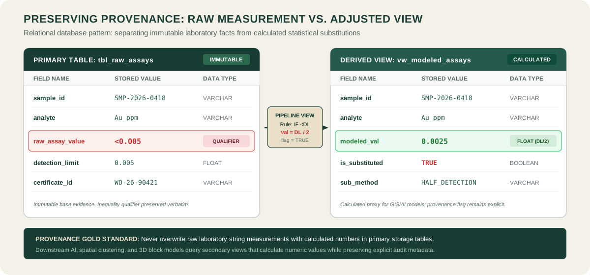
The foundational rule of geochemical data provenance is clear. Specifically, raw laboratory measurements must remain uncorrupted by statistical adjustments or geological interpretations. Geochemical datasets frequently contain assay values below analytical detection limits. However, statistical algorithms cannot process non-numeric inequality strings such as “<0.005 ppm”. In response, database users frequently substitute half the lower analytical limit.
However, overwriting the raw laboratory measurement with a calculated substitute permanently destroys evidence traceability. Future geologists cannot tell if a 0.0025 ppm entry reflects an instrument measurement. Alternatively, it might represent an imputed fraction of an unrecorded detection limit from an older technique. Furthermore, while substituting half the detection limit is a convenient operational approximation for routine plotting, advanced spatial modeling of heavily censored datasets often requires rigorous statistical methods like regression on order statistics or Kaplan-Meier estimation.
Therefore, the compliant architectural solution maintains raw assay readings and inequality qualifiers in immutable base tables. Meanwhile, secondary analytical views store calculated substitutes, detection limit thresholds, and imputation flags (substitution_method = DL/2). As a result, geochemists can execute compositional data transformations on derived tables. Consequently, they retain an uncompromised audit trail back to the physical assay certificate.
Provenance in AI-assisted geological analysis
Automated machine learning models and AI exploration agents exacerbate the need for rigorous data provenance. Machine learning algorithms process massive volumes of drillhole tables, regional geochemical surveys, and geophysical rasters to generate prospectivity targets. An AI tool may operate without traceable links to underlying drillhole evidence. In that case, exploration teams cannot verify whether a proposed target reflects real enrichment or legacy database noise.
Consequently, deploying a specialized geology AI agent requires direct connectivity to certified database records. Autonomous agents evaluating geochemical prospectivity face strict requirements. Specifically, they must verify that input samples share compatible digestion methods before running statistical comparisons.
Teams frequently review multivariate geochemical clusters or spatial anomalies. In response, modern geology data analysis software presents underlying laboratory certificates and sample identifiers, ensuring exploration investments remain grounded in verifiable facts.
FAQs
What does data provenance establish in an exploration audit?
Data provenance establishes the verified custody and transformation trail of exploration data. In a resource audit, it demonstrates that every reported grade, downhole survey, and collar location originates from accredited laboratory certificates or documented field surveys, confirming that estimates rest on defensible geological facts.
What is the difference between data provenance and data lineage?
Data lineage describes the technical pathway data travels through digital transformation pipelines between source tables and downstream systems. Data provenance includes data lineage but extends further by capturing institutional context, including certified laboratory analytical methods, calibration standards, instrument detection limits, and the human sign-offs that validate each measurement.
What does data provenance mean in geology?
In geology, data provenance means recording every attribute required to verify the physical origin and analytical integrity of geological records. This encompasses sample collection methods, core recovery percentages, downhole survey instruments, certified laboratory certificates, analytical digestion techniques, and explicit distinctions between raw measurements and interpreted wireframes.
How do you trace an assay value back to its source?
You trace an assay value back to its source by cross-referencing its sample identifier and laboratory work order against the primary certificate of analysis issued by the testing facility. The audit trail confirms the analytical method, digestion protocol, lower detection limit, quality control results, and sample interval depth.
What should a geological database record about each sample?
A geological database should record the unique sample identifier, borehole or trench coordinates, depth interval, lithological description, sample collection date, laboratory facility, analytical method code, certificate number, measurement units, lower detection limits, quality assurance results, and any subsequent numeric adjustments.
Is data provenance the same as mineral traceability?
No. Mineral traceability tracks physical mineral products from mine extraction through processing, transport, and manufacturing to certify supply-chain origin and regulatory compliance. Geological data provenance tracks the digital lifecycle and analytical history of exploration measurements, borehole intervals, and geochemical assays.
How does AI affect data provenance in geological analysis?
AI increases the necessity for strict data provenance because machine learning models produce unreliable conclusions when fed unverified legacy data. AI agents require auditable data lineage to verify that training datasets use consistent analytical digestions and to present verifiable evidence linking model predictions to primary drillhole observations.
Try It With Geocluster
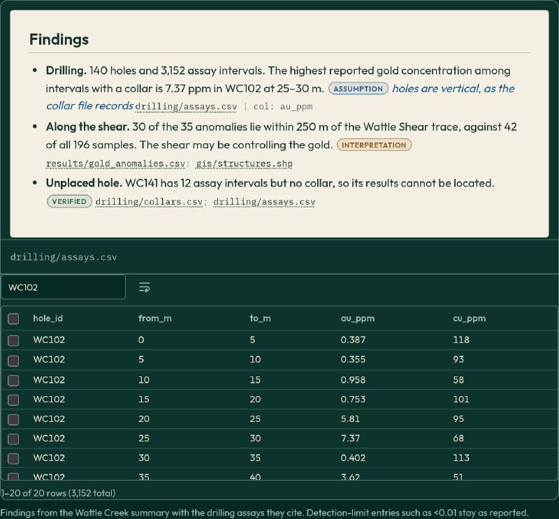
GeoCluster is a browser-based AI agent designed for exploration geologists who require rigorous data provenance and verifiable analytical evidence. Available in open-source and Enterprise editions, GeoCluster connects directly to geological and geochemical datasets to accelerate mineral investigation without compromising data integrity.
The platform processes complex exploration tables with automated length-weighted compositing for drillhole intervals, treats below-detection assays as half the analytical limit while maintaining visible transformation flags, and preserves strict evidence traceability linking every generated interpretation back to its primary laboratory source. Explore the open-source codebase on the GeoCluster research harness repository to deploy audit-ready AI workflows across your mineral exploration projects.