Key Takeaways
- The task today: Geologists use geological data management software to store and check drilling records, rock chemistry and maps, while GeoCluster and open-source tools help them analyse that information once it is safely in the database.
- Databases protect data but do not interpret it: A database keeps exploration files organised and prevents errors like duplicate depths or impossible coordinates, but it does not find patterns or decide where to drill next.
- Analysis tools connect alongside the database: Geologists connect separate analysis software to group chemical samples and spot mineral targets without altering original laboratory measurements or detection limits.
- Traceability keeps predictions honest: Defensible exploration decisions require keeping every map target and calculated anomaly linked to the original laboratory rock assay certificate and field collection records.
TL;DR
Geological data management software keeps exploration records organised, clean and protected, but storing data is only the first step. To discover patterns and choose where to drill, geologists need analysis tools that connect to the database without corrupting original records. This guide compares leading database platforms and shows how dedicated analysis software, including GeoCluster and open-source tools, turns stored data into practical exploration targets.
What does geological data management software do?
Geological data management software is specialised database software that captures, validates, stores and governs exploration and mining records. It centrally manages drillhole collars, downhole surveys, geochemical assays, lithology logs and quality assurance protocols. By enforcing strict relational rules, geological database software ensures that exploration data remains compliant, auditable and protected throughout the mine lifecycle.
This guide targets exploration managers, database administrators, project geologists and resource estimation teams across junior exploration companies, contract drilling programmes and corporate mining operations. Operational requirements vary significantly across these groups. Junior exploration teams managing remote field camps prioritise rapid cloud deployment and offline logging, whereas corporate producers require enterprise governance, multi-user permissions and rigorous audit trails for public reporting.
Before data enters a central repository, legacy paper records and archives often require pre-processing. Exploration teams frequently use PDF table extraction to convert historical drilling reports into structured tabular files without introducing transcription errors.
Similarly, historical cartography must be converted into digital layers before database ingestion. Workflows for digitising old geological maps extract spatial features from raster scans so coordinates match modern geographic projections.
A documented example of this process is AI recovering borehole data from Soviet-era geological maps, where vectorisation software extracted hand-drawn borehole coordinates directly into structured tables.
Best geological data management software compared
As of 2026, this curated shortlist evaluates leading exploration database and subsurface governance platforms based on vendor specifications, industry adoption and data integrity capabilities. Rather than an arbitrary numerical ranking, we evaluate each platform against five core criteria: relational drillhole data modelling, automated QA/QC assay validation, regulatory auditability, deployment architecture (cloud software-as-a-service versus enterprise client-server) and interoperability with downstream analysis and 3D modelling packages.
While commercial platforms increasingly offer visual drillhole displays, data management remains distinct from interpretive modelling. Relational databases enforce sample-level referential integrity and legal custody, whereas 3D modelling packages compute surfaces and interpolations. A collaborative platform like Seequent Central bridges this gap by managing 3D model versions and peer reviews rather than serving as a tabular assay repository.
Comparison of leading exploration database platforms
| Software | Deployment & Licensing | Offline & Field Access | Integration & Data Transfer | Key Validation & Governance | Best For |
|---|---|---|---|---|---|
| acQuire GIM Suite | Enterprise (Server/Cloud) | Dedicated field capture client with offline sync | Direct ODBC connections, Leapfrog and Surpac connectors | Strict QA/QC protocols, sample tracking, audit trails | Mid-tier to major mining companies needing corporate compliance |
| Datamine Fusion | Enterprise client-server | Offline remote drillhole logging module | Direct integration with Datamine Studio, SQL views | Configurable validation rules, downhole survey checks | Multi-commodity corporate operations and established mines |
| Geobank | Enterprise / Cloud-ready | Offline field logging forms with local cache | SQL Server database, ODBC connections, CSV exports | Visual data validation, custom business logic, audit logging | Exploration teams designing custom data entry workflows |
| MX Deposit | Cloud SaaS subscription | Native offline mobile and tablet logging with auto-sync | REST API, cloud exports to CSV/GIS, Leapfrog integration | Real-time logging rules, role-based cloud access | Fast-growing juniors and remote drilling programmes |
| maxgeo DataShed | Cloud / Hybrid hosting | Field logging tools with local cache synchronisation | Automated lab certificate loader, ODBC to modelling tools | Automated CRM tolerance checks, duplicate analysis | Exploration and resource estimation teams |
| Plexer | Cloud SaaS subscription | Web-based capture with scheduled batch synchronisation | Multi-format data mapping, cloud REST API, file exports | Automated column layout standardisation, central storage | Multi-project exploration management with diverse contractors |
| Seequent Central | Cloud subscription | Local caching with cloud model synchronisation | Direct Leapfrog and Oasis montaj connector, web API | 3D model revision control, branch-and-merge tracking | Geological modelling teams managing 3D interpretation versions |
Enterprise geological database software
Enterprise platforms are designed for operations that require multi-user governance, custom SQL schemas and corporate compliance.
acQuire GIM Suite is widely deployed across enterprise-scale mining companies for structured resource governance. According to vendor documentation, it provides configurable validation engines for laboratory assay certificates and enforces chain of custody protocols from rig-side logging to corporate sign-off.
Datamine Fusion delivers a centralised relational environment connecting drilling records to downstream mine planning software. It manages complex downhole survey calculations, lithological code libraries and geotechnical interval measurements.
Geobank, developed by Micromine, focuses on visual data validation and flexible data models. It allows exploration teams to design custom data entry forms with real-time error trapping, preventing erroneous collar coordinates from entering production tables.
Cloud exploration data management software
Cloud exploration data management software offers rapid deployment without the capital expense or maintenance overhead of dedicated database servers.
MX Deposit provides a modern software-as-a-service environment tailored for logging drill core and surface samples. Geologists can log core on mobile devices in remote camps without internet connectivity, with data synchronising automatically once a connection is established.
maxgeo DataShed connects field data capture with centralised laboratory assay management. It automates the verification of certified reference materials, blanks and duplicates, notifying database managers when incoming laboratory batches exceed configured quality thresholds.
Plexer aggregates exploration data from disparate drilling contractors and commercial assay laboratories into a single cloud repository. It standardises disparate column layouts upon upload, creating a consistent master dataset across multi-commodity exploration portfolios.
Project data and version control
Managing 3D geological models requires specialised version control that complements tabular database software.
Seequent Central functions as a collaborative version-control platform for subsurface models rather than a tabular sample database. It tracks model revisions, enables peer reviews and ensures that entire geological teams build their interpretations from the exact same validated database snapshot.
How to choose geological data management software
Selecting the best exploration software for your team requires matching technical capabilities to your operational scale, field connectivity and regulatory requirements.
- Validation rules and QA/QC automation: The software must automatically verify incoming assays against configured reference thresholds. Certified reference materials (CRMs) typically fail when assays deviate beyond two standard deviations (warning) or three standard deviations (failure) from certified values. Blanks fail when analyte levels exceed three to five times the detection limit, indicating sample carryover. Duplicate pairs must meet precision limits evaluated via Relative Percent Difference. A platform that allows failing batches into production tables compromises resource calculations.
- Drillhole data model support: Ensure the system natively supports collar, survey, assay, lithology, alteration and geotechnical tables with strict parent-child referential integrity, preventing orphan intervals or overlapping depths.
- Audit trails and regulatory disclosure: Under international reporting codes like JORC (2012 Table 1 Section 1) and NI 43-101 (Form 43-101F1 Items 11 and 12), Competent and Qualified Persons must verify data accuracy, sample security and verification procedures. While reporting standards mandate transparency and verification rather than specific software brands, exploration teams require software with tamper-evident, timestamped audit trails tracking who created, edited or approved every interval.
- Integration with downstream tools: Your chosen geological data management system must export cleanly via ODBC, REST APIs or structured files to industry standard 3D geological modelling packages.
Drillhole database software essentials
Every drillhole database software package must enforce spatial integrity before records are approved. Automated database rules verify that coordinates fall within defined numeric bounds, that UTM zones match valid geographic numbering (1 to 60), and that downhole dip angles do not exceed physical inclinations (-90° to +90°). In contrast, identifying whether drillhole deviations exhibit excessive dogleg severity, whether collar elevations match LiDAR topography, or whether magnetic declination was applied correctly requires geoscientific domain review.
Coordinate reference systems combine a geodetic datum (such as WGS84, GDA2020 or NAD83) with a map projection system (such as Universal Transverse Mercator or UTM). Storing coordinates without an explicit coordinate reference system or combining datasets across differing datums without mathematical transformation can introduce systematic offsets of tens of metres, distorting drillhole spacing and block models.
Enterprise database platforms enforce programmatic coordinate resolution before records enter spatial tables. Validation routines parse user-supplied coordinate specifications, verify UTM zone numbers between 1 and 60, and map local grids to canonical EPSG codes such as EPSG:4326 or local projected systems. In relational database schemas, mandatory foreign key constraints link collar coordinates to downhole survey intervals and assay records. When coordinates fall outside geographic bounding limits or fail projection rules, the system raises data validation errors to prevent corrupted spatial records from entering downstream exploration models.
Geological data analysis software: analysing data once in the database
A database protects your records, but it does not tell you where mineralisation concentrates. Exploration teams need geology data analysis software to investigate relationships across multielement geochemistry and structural contacts.
Databases store assays as isolated numbers in relational rows. In contrast, analysis platforms run geochemical clustering, compute length-weighted compositing and calculate anomaly ranking metrics across thousands of intervals.
GeoCluster, developed by Eigenform, is an AI-assisted geological investigation harness. Operating as an analysis layer alongside existing database software rather than replacing database storage, it ingests structured exploration tables (such as CSV, GeoJSON and Shapefiles), executes analytical routines, and exports target rankings without modifying authoritative base tables.
To accelerate targeting, teams connect geochemical clustering and anomaly tools directly to database extracts. These tools isolate anomalous element associations without mutating the underlying raw database records.
Using an autonomous geology AI agent allows teams to evaluate multivariate exploration data in seconds, keeping every interpretive result traceable back to specific assay certificates.
How geological data management and analysis software work together
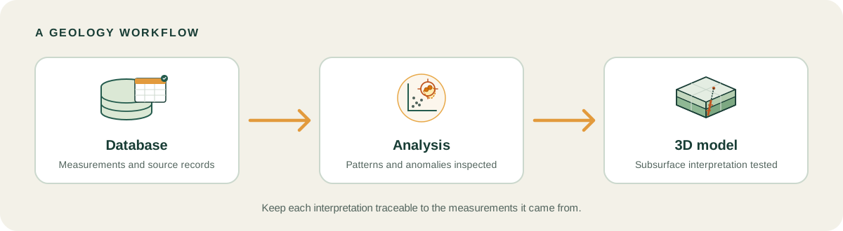
Effective exploration teams treat data management and data analysis as complementary stages in a unified pipeline.
- Ingestion and validation: Collar, survey, lithology and assay records enter the database, where automated checks verify coordinate reference systems, intervals and QA/QC standards.
- Authoritative lockdown: Base tables are locked with timestamped audit records, creating a clean, versioned extract for exploratory analysis.
- Multivariate analysis: Analytical software connects to the clean extract, preserves assay qualifiers, computes length-weighted composites, and clusters geochemical pathfinder elements.
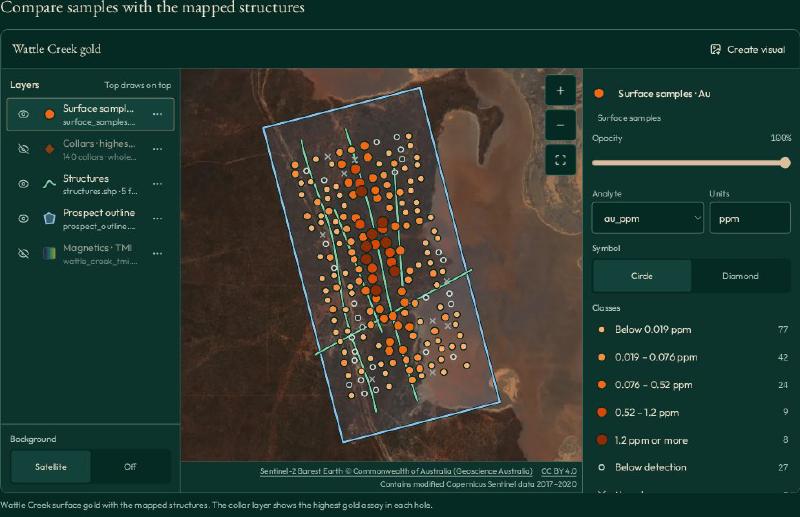
- Target ranking: Geologists rank anomalous drillhole intervals and evaluate spatial clustering against mapped fault structures.
- Modelling integration: Validated anomalies and structural contacts import into best geology software to generate 3D wireframes and grade interpolations.
- Provenance tracking: Teams inspect mineralised envelopes using an interactive 3D voxel model demo, where every drillhole pierce point remains traceable to its primary assay certificate and QA/QC batch.
Defensible traceability requires that every interpreted target or resource block links back to a minimal provenance record: the primary laboratory assay certificate ID, sample interval ID, un-substituted raw measurement, detection limit qualifier, QA/QC batch approval status, analytical method code, and the timestamp and identity of the geologist who approved the interpretation.
What to watch for: validation limits and data gaps
Even top-tier database software cannot prevent errors if operational protocols are flawed.
- Distinguishing censored, missing, and failed assays: Databases must never collapse distinct assay states into a single numeric zero, null or dummy value. A measured value below analytical detection is a censored measurement requiring preservation of the qualifier and detection limit. An unassayed interval indicates pending analysis or lost core. A failed QA/QC assay denotes an invalidated batch requiring laboratory re-run. An unsampled interval reflects unmineralised rock that was deliberately not sampled. Databases must maintain dedicated qualifier flags and status codes for each condition.
- Handling values below detection limits in analysis: In the authoritative database, preserve original reported values and laboratory qualifiers verbatim. While downstream statistical routines often substitute values below detection (such as half the detection limit, regression on order statistics, or Kaplan-Meier estimation) to calculate numerical summaries, performing blind substitution directly inside primary database tables corrupts audit records and distorts statistical distributions when batches have differing detection limits.
- Coordinate reference system and datum transformations: Ensure every spatial dataset explicitly records its geodetic datum and projection parameters. Combining coordinates across differing datums without rigorous mathematical transformation creates coordinate shifts that misalign collars and surface trenches.
- Unvalidated collar elevations: Digital elevation model discrepancies frequently lead to floating or buried drillhole collars. Always reconcile GPS elevations against high-resolution topographic surfaces.
FAQs
What is geological data management software?
Geological data management software is a dedicated database platform designed to capture, validate, store and audit exploration records. It centrally manages drillhole collars, downhole deviation surveys, laboratory assay certificates, lithological logging and quality control records. By enforcing relational rules and audit trails, it ensures exploration records remain compliant and defensible throughout drilling programmes.
What is the best geological database software?
The best software depends on project maturity, connectivity and team requirements. In our curated 2026 evaluation, acQuire GIM Suite and Datamine Fusion lead enterprise operations requiring multi-user governance and compliance. For junior exploration teams and remote camps requiring rapid deployment and offline mobile logging, MX Deposit and maxgeo DataShed provide scalable cloud-native platforms.
What should a drillhole database include?
A comprehensive drillhole database must include collar coordinates, downhole deviation surveys, interval assay measurements, lithological logging, structural readings and quality control batches. It must enforce relational parent-child integrity, coordinate reference systems, interval continuity from surface to end-of-hole, certified reference standard tracking and timestamped audit logs documenting who created, modified or approved every record.
What is the difference between a geological database and modelling software?
A geological database stores, validates and audits factual empirical measurements, such as collar surveys, assay certificates and lithology logs. In contrast, geological modelling software ingests those validated tables to construct interpretive three-dimensional wireframes, fault networks, grade interpolations and block models used to estimate mineral resources and plan future exploration targets.
Can I analyse data directly in the database?
Relational databases are engineered for secure record storage and transactional integrity, not complex exploratory data analysis. While you can run basic SQL filters, advanced tasks such as multivariate geochemical clustering, pathfinder anomaly ranking and spatial correlation require dedicated analysis software that queries the clean database tables without modifying underlying raw values.
How do I check data quality before analysis?
Check data quality by confirming coordinate reference systems, verifying interval continuity, and validating quality control batches. Ensure certified standards fall within two or three standard deviations, blanks show no contamination, and duplicate pairs meet precision tolerances. Preserve raw assay qualifiers and laboratory detection limits before applying any analytical substitutions downstream.
Try It With Geocluster
Open GeoCluster to investigate geological exploration data directly in your web browser with an AI agent, without requiring software installation or server configuration.
To learn more about connecting geological databases to downstream 3D interpretation tools, explore our companion guide on best geology software for modern exploration teams.