Key Takeaways
- The task today: Exploration teams must verify historical drilling data before investing in new drilling or resource modelling. They traditionally rely on desktop software to confirm that legacy drill records match real ground positions.
- The problem: Legacy drill datasets frequently suffer from collar surveying mistakes, missing coordinate datums, and unverified assay certificates. These flaws cause automated AI workflows to misplace mineral boundaries or generate distorted subsurface models.
- What the tool does: GeoCluster is a browser-based AI agent for geological investigation, open-source or Enterprise. It analyses verified drillhole tables with length-weighted means, treats below-detection assays as half the limit, and keeps raw measurements apart from interpretation.
TL;DR
Before entering historical drilling records into modern resource models, exploration geologists must verify legacy drillhole collars, downhole intervals, and laboratory assays. Older exploration campaigns frequently lacked standard quality control and modern downhole surveys. They relied on local coordinate grids and small-diameter core that introduce spatial distortions or grade biases. By validating database logic, re-assaying archived samples, and using automated coordinate tools, teams ensure legacy exploration data remains defensible and audit-ready.
What is historical drilling data, and why must you verify historical drilling data before use?
Historical drilling data comprises legacy borehole logs, collar coordinates, downhole surveys, and geochemical assays collected by previous operators or during earlier exploration campaigns. Often preserved only as paper drill logs, PDF reports, or unvalidated spreadsheets, this information requires systematic verification before inclusion in modern 3D models or compliant mineral resource estimates.
Drilling data always reflects the technical standards of its era. Protocols for surveying, sample recovery, laboratory assaying, and quality control have changed substantially over the past half-century, and what was accepted practice in the 1960s often fails modern standards under international reporting codes like JORC or NI 43-101.
As Janne Hokka, resource geologist at the Geological Survey of Finland (GTK), emphasises, historical drilling data should never be trusted blindly. In many instances, historical data cannot enter an official resource database even after verification. However, when properly vetted, legacy exploration data provides essential geological context that accelerates exploration targeting.
Why early drilling campaigns contain hidden flaws
Between the 1950s and the 1970s, mineral exploration relied heavily on lightweight drill rigs. Rigs such as Winkey drills or T-46 machinery produced small-diameter core measuring only 22 mm or 32 mm.
As the GTK review points out, small-diameter core created two persistent data quality issues:
- Unmeasured downhole deviation: Small drilling strings deviated significantly, and early exploration teams lacked instruments for accurate downhole surveying. In legacy databases, holes recorded as straight trajectories could lie far from their true positions.
- Sample representativeness and the nugget effect: Small sample volumes struggle to capture representative mineralisation in gold exploration due to the nugget effect. When combined with core loss in fractured, prospective mineralised zones, historical drilling systematically under-reported grades.
Modern industry practice relies on NQ (47.6 mm) or HQ (63.5 mm) drilling to ensure sample representativeness and structural stability.
Analytical laboratories have also evolved. While fire assay with atomic absorption spectroscopy (FAAS), developed in the 1960s, became a popular method for analysing precious metals in commercial laboratories, early laboratories rarely implemented modern quality control (QAQC) systems. They seldom inserted certified reference materials (standards), coarse blanks, or pulp duplicates to monitor instrument drift and contamination. Furthermore, early exploration teams often neglected bulk density determinations, creating severe uncertainties for downstream tonnage calculations.
Step 1: Historical drill hole data validation to verify historical drilling data
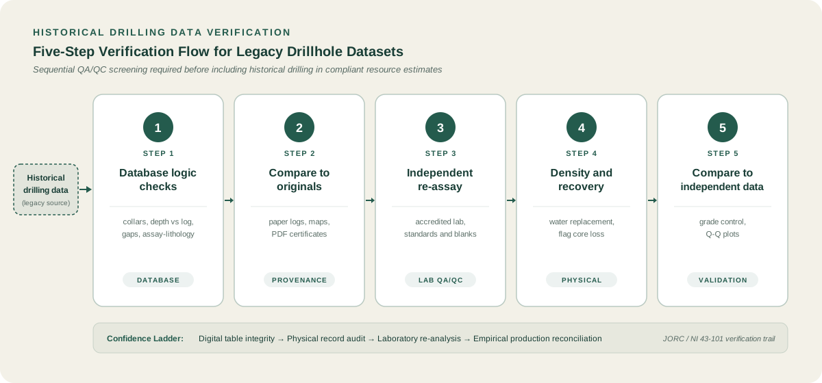
Before examining physical core archives, teams verify historical drilling data by validating the digital database itself, where logic checks provide the fastest filter for identifying contradictions.
Many inherited databases contain clerical errors, contradictory depth intervals, and spatial misplacements. Teams perform automated logic checks inside specialized geological data management platforms before moving records into production environments.
Catching drillhole database errors before modelling
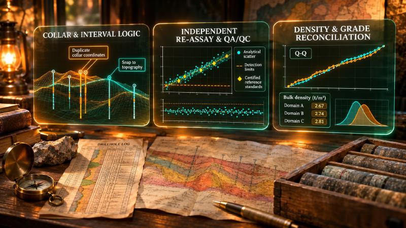
As Jake Anderson outlined for Maptek (2019), five core validation checks reveal the vast majority of drillhole database errors:
- Unique collar locations: Every borehole requires a distinct collar coordinate. When two holes share identical coordinates, it usually indicates redrilling after an obstruction, a twinned hole, or a clerical numbering error. If twinned holes exist, geologists must determine the authoritative record and isolate the extraneous data.
- Total depth versus final lithology interval: A recorded total depth (TD) must match the bottom depth of the final logged lithological interval. Discrepancies occur when drillers logged total drilled depth but sampling stopped higher up. If original paper logs are inaccessible, geologists stop total hole depth at the last verified logged interval.
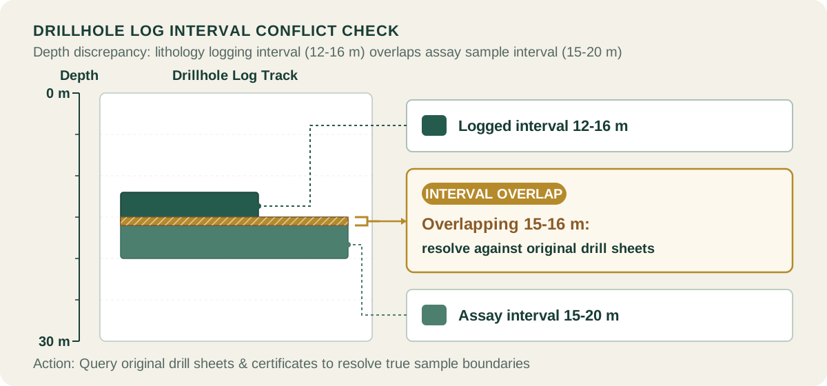
- Overlapping intervals and depth gaps: Lithology and sample intervals down a drillhole must form a continuous sequence of
from_mandto_mdepths. Overlapping intervals or unlogged gaps corrupt spatial compositing algorithms. Teams must resolve these errors against original drill sheets, core photographs, or downhole geophysical logs. - Assay intervals conflicting with lithology contacts: Assay sample boundaries should respect major geological contacts. When an assay interval crosses a sharp lithological contact, it may indicate inaccurate lithology picks or artificial grade dilution.
- Collar elevation versus pre-mine topography: Collar coordinates often require elevation adjustments due to early GPS inaccuracies or local survey grids. However, exploration collars must be reconciled against historical pre-mine topography rather than an active open-pit mining surface.
Key validation checks for historical drillhole databases
The table below summarizes these five checks with typical error symptoms, corrective actions, and resource model flags:
| Validation Check | Common Error Identified | Operational Fix | Resource Model Flag |
|---|---|---|---|
| Collar Uniqueness | Duplicate coordinates from redrills or twinned holes | Verify hole provenance; select primary hole; isolate redrill | Flag subordinate hole as non-resource |
| Total Depth vs Log | Hole logged to 120 m but database lists TD as 145 m | Check driller shifts; truncate TD to last confirmed logged interval | Record truncation depth in metadata |
| Interval Continuity | Overlapping samples (e.g. 12-16 m and 15-20 m) or gaps | Cross-check original drill sheets or core photography | Hold intervals in audit quarantine |
| Assay vs Lithology | High-grade assay crossing barren contact by 0.5 m | Re-examine lithology picks; adjust sample boundaries if logged | Flag potential grade dilution |
| Topography Snap | Collars floating above surface due to local grid shift | Transform using verified control points to pre-mine digital elevation | Tag with elevation adjustment method |
Step 2: How to verify historical drilling data against original logs and reports
Database validation proves internal numerical consistency, but it cannot confirm geological reality. The second essential phase to verify historical drilling data requires cross-referencing digital records against original paper sheets, drillers diaries, and laboratory certificates.
Checking lithology against the original sheets (GTK) reveals whether historical geologists collapsed distinct volcanic facies or alteration zones into broad rock categories. Geologists must also verify whether collar coordinates were recorded in a local mine grid or an older regional datum, and that coordinates were transformed correctly into modern world coordinates.
Where historical records exist only as paper maps or scanned PDF documents, modern digital processing pipelines bridge the gap into structured databases.
Exploration teams use specialized machine learning workflows for AI recovering borehole data from Soviet-era geological maps, which reconstruct coordinates and stratigraphic columns directly from archived cartographic folios.
Teams convert paper maps into spatial layers by digitising old geological maps, ensuring historical collar plans align with modern satellite imagery and mineral tenure boundaries.
Automated pipelines also extract tabular drill records using PDF table extraction, turning scanned laboratory reports into verified database rows without manual re-keying errors, preserving columns such as hole_id and au_ppm.
These tools integrate with comprehensive geological map processing systems that preserve raw image coordinates alongside transformed geographic features.
Step 3: How to verify historical drilling data with independent re-assaying
When archived drill core or coarse sample rejects remain physically accessible, independent re-assaying provides definitive evidence of analytical reliability. A rigorous program to verify historical drilling data must test analytical accuracy across diverse mineralised domains.
Following the GTK verification framework and the Canadian Institute of Mining, Metallurgy and Petroleum (CIM) Mineral Exploration Best Practice Guidelines (2018), re-assay programs must adhere to rigorous quality criteria:
- Representative sampling: Select a statistically representative subset of intervals across all major mineralisation styles, host lithologies, and grade ranges, from low-grade mineralised envelopes to high-grade feeder zones.
- Accredited modern laboratories: Submit all check samples to an independent accredited laboratory using modern analytical protocols, such as multi-element four-acid digestion with ICP-MS finish and fire assay with gravimetric or spectroscopic finishes.
- Systematic QA/QC insertion: Integrate certified reference materials, blanks and duplicates into every analytical batch to monitor accuracy, contamination and precision.
Geologists must record the exact analytical detection limit and laboratory qualifier code for every interval. Never convert non-detect strings into bare numerical zeros.
Step 4: Verify historical drilling data for density and core recovery
A mineral resource estimate relies on three primary variables: grade, volume, and bulk density. When teams verify historical drilling data, validating rock density is just as critical as confirming grades, because resource tonnage scales directly with bulk density. Yet, as Janne Hokka emphasised, bulk density is routinely neglected during exploration.
Many historical exploration projects either omitted density testing entirely or assigned single assumed specific gravity values across entire geological formations, an unverified assumption that introduces proportional error into project economics.
GTK recommends conducting systematic bulk density measurements across all estimation domains using the water replacement method. Dedicated QA/QC procedures monitor the accuracy and precision of those measurements.
In parallel, exploration teams must evaluate historical core recovery data. In friable shear zones or intensely altered ground, drillers frequently suffered severe core loss. If core loss coincided with high-grade mineralised veins, historical sampling may have distorted average grades. Where core recovery was poor and cannot be independently confirmed, geologists must flag the affected intervals. This restriction limits their influence in resource estimation.
Step 5: Verify historical drilling data against grade control and production
When physical core no longer exists and QAQC records consist only of summary reports, teams verify historical drilling data in brownfield projects by comparing legacy intercepts against grade control or active mine production.
A prominent example is SRK’s resource assessment of the giant Muruntau gold mine in Uzbekistan. Muruntau was explored through extensive surface drilling and underground channel sampling conducted under the historical Soviet GKZ system. While exploration followed GKZ protocols, modern teams obtained only summary quality control reports. Furthermore, historical drill core was unavailable for physical re-logging.
To evaluate data quality for reporting under the JORC Code, SRK employed an alternative validation methodology:
- Grade control block modelling: SRK constructed a detailed grade control block model in Leapfrog, confirming that its estimates aligned with historical production records.
- Paired composite analysis: After reconciling the block model with production, SRK paired modern grade control data with historical exploration composites located within close spatial proximity.
- Quantile-Quantile (Q-Q) plots: Rather than relying exclusively on global summary statistics, SRK used Q-Q plots to evaluate distributions across the full spectrum of grades. Summary statistics often obscure local grade biases.
The Q-Q plots revealed specific grade ranges where historical sampling displayed relative bias. Because the production reconciliation and statistical comparisons demonstrated overall consistency, SRK achieved sufficient confidence in the historical database. Consequently, they assigned the Indicated resource classification under the JORC Code, establishing the foundation for declaring ore reserves.
How to verify historical drilling data and record data provenance
Verifying historical drilling data is an ongoing discipline of data governance rather than a one-time cleaning script, and every database correction requires an immutable audit trail for compliant reporting.
Exploration teams should maintain a permanent audit log that records:
- The exact source document identifier, such as the drill log sheet number or the original
hole_id. - The identity of the geologist who reviewed and approved the modification.
- The original recorded value and the updated value.
- The technical justification and verification method applied, such as collar resurveyed with differential GPS or assay re-analysed at an accredited laboratory.
Modern teams configure an autonomous geology AI agent to monitor data ingestion pipelines. The agent checks spatial coordinates and flags interval overlaps as new records enter the system.
Authoritative base tables must remain permanently locked. Downstream geological modelling and spatial clustering should execute against versioned, clean analytical extracts. In this way, every interpreted contact, geochemical anomaly, and resource block remains provably traceable back to primary physical measurements.
Analysing verified historical drilling data with modern software
Teams connect the validated tables to modern geology data analysis software for target generation and exploratory analysis.
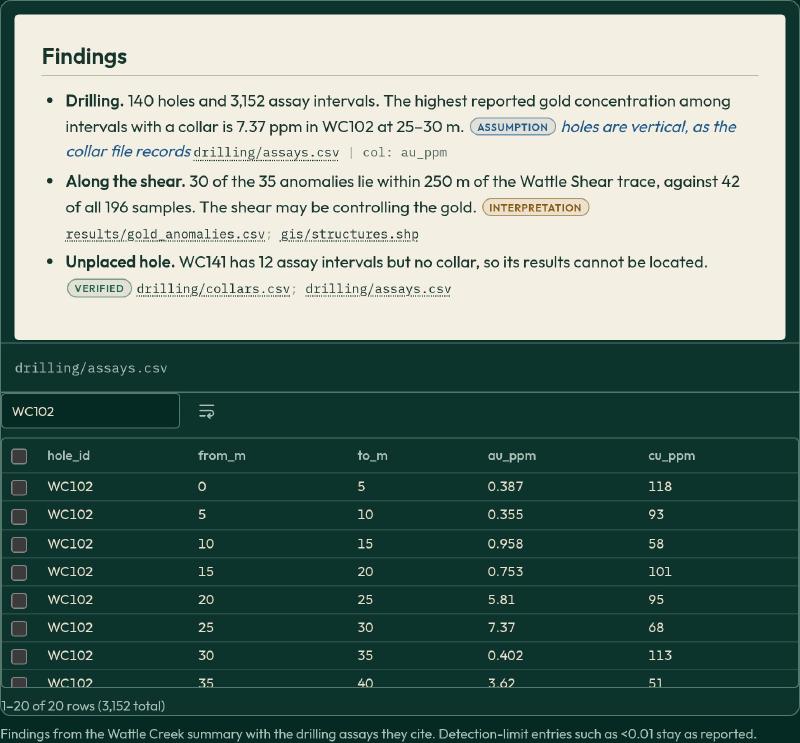
GeoCluster operates as an AI-assisted analytical harness alongside existing database software. Operating directly in the web browser, it ingests structured exploration tables without modifying authoritative base tables.
GeoCluster provides length-weighted compositing for drillhole intervals. It treats below-detection assays as half the analytical limit for numerical clustering. Furthermore, it maintains complete evidence traceability by keeping raw measurements strictly separate from interpretive models. It supports standard exploration formats including CSV, TSV, XLSX, PDF, GeoJSON, Shapefiles, GeoTIFF, and NumPy volumes.
What to watch for when you verify historical drilling data
Even thorough verification programs encounter technical limits when handling legacy exploration data:
- Uncalibrated historical collar elevations: GPS units used in early exploration lacked differential corrections, so their vertical errors could be substantial. Always reconcile historical collar elevations against high-resolution modern digital elevation models.
- Selective sampling bias: Early exploration campaigns frequently assayed only obviously mineralised core. They left surrounding low-grade or barren rock unassayed. Inserting artificial
0values into unassayed intervals distorts grade estimation. Conversely, treating them as missing data can overestimate mineralised volumes. - Legacy coordinate datum conversions: Converting between regional historical datums and modern coordinates requires precise transformation parameters; simplified approximations cause systematic shifts that misalign historical collars with modern drilling grids.
FAQs
How do you verify historical drilling data?
To verify historical drilling data, geologists apply a systematic three-layer validation process. First, teams run database logic checks to catch duplicate collars and overlapping intervals. Second, they compare digital tables against original paper drill sheets, re-assaying archived core at accredited laboratories with modern quality control. Finally, they reconcile historical intervals against independent grade control data.
What are common errors in historical drillhole databases?
Common errors in historical databases include duplicate collar coordinates caused by unrecorded redrilling, mismatched total depths where drilling stopped beyond sampled intervals, and overlapping sample boundaries. Furthermore, legacy datasets frequently suffer from unmeasured downhole deviations, missing bulk density determinations, and collar elevations snapped to active mining surfaces rather than historical pre-mine topography.
Can historical drilling data be used in a resource estimate?
Historical drilling data can support mineral resource estimates under modern reporting standards like JORC and NI 43-101 only after rigorous verification. When physical core, original assay certificates, and documented quality control are unavailable, Qualified Persons typically restrict unverified legacy data to the Inferred category or require confirmatory twin drilling before upgrading resources to Indicated.
Do I need to re-assay old core?
You should re-assay archived core whenever historical quality control records are absent or incomplete. Early drilling programs frequently lacked certified reference materials, blanks, and duplicates. Submitting a representative subset of historical intervals to an accredited laboratory confirms analytical accuracy, reveals potential calibration bias, and establishes defensible detection limits for modern resource estimation.
What if the original core no longer exists?
If original drill core has been destroyed or discarded, teams cannot conduct physical check assays. Instead, geologists must validate database logic against surviving paper logs and evaluate spatial consistency. In active mines, teams use statistical reconciliation, pairing historical composites against modern grade control data and analysing Q-Q plots to detect grade-range biases.
How do I handle missing density data?
Never assign a single assumed specific gravity across an entire deposit without physical evidence. If historical density is missing, geologists should collect new density measurements from surviving core across every lithological and alteration domain using the water replacement method. If core is unavailable, teams must conduct dedicated confirmatory drilling to establish spatial density models.
What should I document when I clean legacy data?
Exploration teams must maintain a comprehensive, immutable audit trail for every modified record. Documentation should record the source document identifier, the reviewing geologist, the modification timestamp, original values alongside corrected entries, and the technical justification. Keeping raw legacy databases locked ensures all analytical adjustments remain transparent, defensible, and fully audit-ready.
Try It With Geocluster
The geochemical clustering and anomaly tools in GeoCluster make this verified data work harder: a browser-based AI agent for geological investigation, open-source or Enterprise, that analyses the tables this process produces.
To explore how to interpret verified subsurface intervals and generate mineral exploration targets, see our companion guide on informed core logging.