Key Takeaways
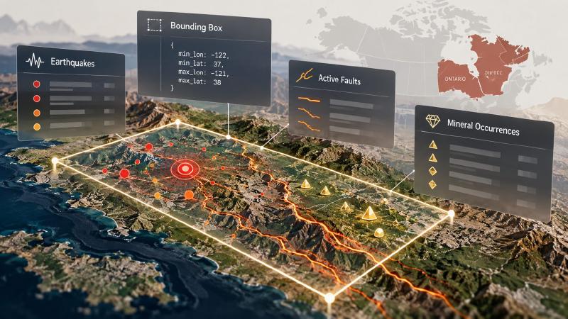
- A bounding box is a rectangle on a map, set by four numbers: how far west, south, east and north it reaches. Geological AI tools use it to ask “what is already known about this area?”
- Give the map program a box anywhere in the world and it looks up past earthquakes and active faults inside it. Faults are cracks in the Earth’s crust that can still move. Mineral finds are the exception: the program checks them only when you ask, and only in two Canadian provinces.
- An empty answer does not mean nothing is there. The program says so in its warnings, and it saves every answer with notes on where each record came from.
TL;DR
You tell the program which rectangle of the Earth you care about. It searches public records of earthquakes and faults for that area, plus mineral finds if you ask. You get a short count, the records themselves and a saved copy to come back to, along with warnings about anything it could not check.
What Is geomap_query_knowledge?
geomap_query_knowledge is the knowledge lookup tool in Stratigraphic Amenity, Eigenform’s open-source (MIT) MCP server for scanned geologic maps. It sends one request to a set of knowledge providers, small adapters around public datasets, and gathers their answers into a single knowledge bundle.
A request needs at least one of three inputs. bounds is a box in longitude and latitude (EPSG:4326), legend_labels drive rock-type and rock-age lookups, and query_text drives semantic search. This post covers bounds, where most geological AI work starts.
Coverage differs by record type:
| Records | Source | Coverage |
|---|---|---|
| Earthquakes | USGS catalogue, plus EMSC on request | Worldwide |
| Active faults | GEM Global Active Faults Database, plus DISS on request | Most active regions worldwide, with known gaps in Canada, Madagascar and the Malay Archipelago; DISS adds Italy |
| Mineral occurrences | Online sources for Ontario and Quebec | Ontario and Quebec only, on request |
A box such as {"min_lon": -122, "min_lat": 37, "max_lon": -121, "max_lat": 38} works with no map at all. The tool rejects boxes that cross the 180th meridian with invalid_bounds.
How Do I Look Up Earthquakes and Faults With AI?
Three settings decide what comes back.
Choose providers with include and exclude
With only a box, the server asks the two providers that are on by default, earthquake_history and active_faults. Mineral occurrences, land cover and population density stay off, and the result names each provider it did not consult.
include picks providers by ID, name or output key, with forgiving spelling. exclude drops one from the default set. A name that matches nothing fails with unknown_provider and lists the registered providers.
Set record limits
Each provider returns at most 50 records by default. max_records sets one limit for every provider, and max_records_by_provider overrides it for one, such as {"earthquake_history": 200}. Earthquakes come newest first, then by magnitude.
The summary counts records, not items, and says when a result was cut. Each item also carries record_count, the number found before the cut. The server once reported “1 item” for a result holding 86 mineral occurrences, and agents misread it, so the wording changed.
Pass provider_options for one source
provider_options passes settings to one provider, keyed by its ID. Earthquakes accept time and magnitude filters (starttime, endtime, minmagnitude, maxmagnitude). They use the primary USGS source unless "source": "all" adds EMSC as well.
The server checks every option before any query runs; an unknown key fails the call.
Mineral occurrences are live-only. With include: ["mineral_occurrences"], the server queries the Ontario and Quebec sources, but only for boxes that overlap those provinces. The Ontario service is a third-party copy of a 2013 snapshot, not the current official inventory.
Knowledge Bundles and Empty Results
Each call saves a new bundle as geomap://bundles/<id>.json, so running the same query twice gives two bundles. A bundle holds the items, every warning, the version of each source and a trace of which providers ran. Each item’s provenance names its source, licence and attribution.
Geological AI agents should read the warnings before the records. A box with no mapped faults returns “No GEM active-fault features intersected the bounds; this is not evidence that no active faults exist.” The GEM fault database covers most active regions worldwide but has known gaps in Canada, Madagascar and the Malay Archipelago, so boxes there get an extra caveat.
Also, the earthquake search reaches 0.05° beyond the box, about 5.5 km, on purpose. The server also caches results on disk with no expiry, so a live source asked the same question again returns its first answer.
FAQs
What can geomap_query_knowledge look up for an area?
By default it looks up recorded earthquakes and active faults inside the box, anywhere in the world. On request it adds mineral occurrences in Ontario and Quebec, land cover and population density from Google Earth Engine, and semantic search over geological text. All the answers land in one saved knowledge bundle.
Why are mineral occurrences missing from my results?
The mineral provider is off by default because it calls live online services. Add "include": ["mineral_occurrences"] to the request. It only covers Ontario and Quebec, so a box elsewhere returns a warning that the area is outside its coverage, which is not evidence that no occurrences exist.
How many records does each provider return?
At most 50 by default. Use max_records to change the limit for every provider, or max_records_by_provider for one. The result reports how many records were found and how many were returned, and marks a cut result as truncated, so an agent knows when to ask for more.
Does an empty result mean there are no faults or earthquakes?
No. It means none were found in that source for that box. Catalogues have gaps, and the server says so in the warnings. A geological AI agent should report an empty result as “none recorded in this source”, naming the source, and never as proof that the area is free of faults.
Try It With Geocluster
Stratigraphic Amenity is one of the Geocluster tools, MCP servers that let AI agents work with geology data and maps.
When a scanned map is already pinned to real coordinates, asking questions about that map fills in the box from that map instead.