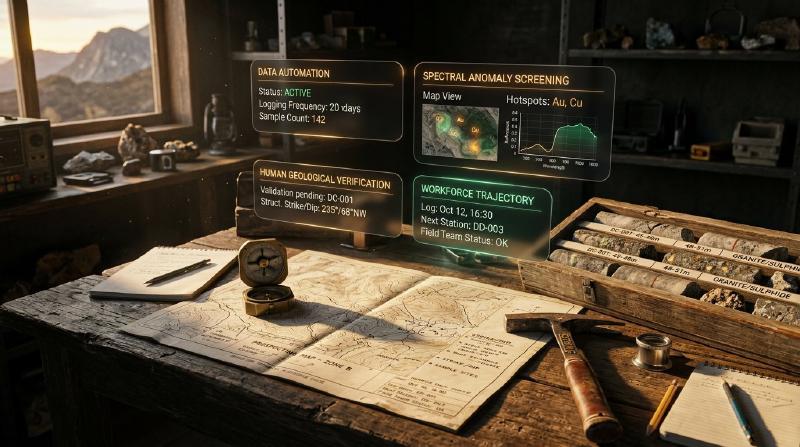
Asking will AI replace geologists is one of the most pressing questions facing exploration teams, mining executives, and geoscience students over the next decade. As machine learning algorithms enter core sheds and regional offices, automated tools accelerate repetitive data formatting and anomaly screening across exploration datasets. However, examining what tools can compute alongside workforce demographics reveals that the collaboration of ai and geologists augments rather than replaces accountable human scientific judgment.
TL;DR
Will artificial intelligence eliminate the profession of geology? Available industry evidence indicates that AI is automating routine data processing rather than replacing human geologists. Computer algorithms accelerate tasks like digitizing paper records, sorting rock photos, and screening regional maps for chemical anomalies. However, deciding where to drill, resolving 3D rock structures, and verifying computer predictions in the field still require accountable human judgment. Consequently, exploration companies face hiring bottlenecks for qualified geologists who can audit automated models.
Key Takeaways
- Artificial intelligence automates repetitive data tasks without eliminating the geology profession. Computer algorithms process sensor data and flag statistical patterns, while professional geologists interpret what those patterns mean underground.
- Routine data extraction and image sorting are the primary tasks open to automation. Software assists by organizing drill core photographs, transcribing historical PDF reports, and highlighting geophysical anomalies across large regional surveys.
- Geological interpretation and drilling sign-off require accountable human verification. Algorithmic models generate exploratory hypotheses that professional geoscientists must evaluate through field mapping, rock sampling, and statutory reporting.
- Workforce demographics in major mining regions show skilled labor shortages rather than job losses. Projected retirements across the United States and lower university enrolments in mining programs mean exploration teams actively seek geologists with data literacy.
Will AI Replace Geologists? What the Evidence Says
Evaluating will AI replace geologists requires distinguishing task automation from professional replacement across exploration workflows. While machine learning accelerates repetitive data formatting, core photography classification, and preliminary geophysical screening, finding mineral deposits requires physical field mapping, 3D structural interpretation, and statutory sign-off. Consequently, computational algorithms augment exploration geologists rather than eliminating the profession.
Specifically, debates over whether will AI replace geologists often confuse three distinct operational questions:
- Eliminating the profession: For instance, whether software can discover economic ore bodies and manage mineral assets without human direction.
- Automating specific sub-tasks: For example, whether computer algorithms can process sensor measurements, transcribe historical reports, and contour geophysical grids.
- Shifting professional responsibilities: In particular, whether working geoscientists spend less time manually compiling spreadsheets and more time supervising algorithmic workflows.
Classifying Evidence: Will AI Replace Geologists?
In addition, to evaluate these questions objectively, exploration managers must differentiate three categories of evidence:
- Task capability evidence: For example, demonstrations measuring the speed and accuracy of specific algorithmic tools on defined datasets.
- Workforce demographic evidence: In addition, demographic surveys measuring industry retirements, university enrolments, and job vacancies.
- AI employment-impact evidence: Furthermore, econometric research measuring net job displacement, wage changes, or task substitution caused by software adoption.
Currently, direct econometric studies measuring net AI-induced job displacement specifically for exploration geologists do not exist. Therefore, while workforce demographic data provides essential context on labor supply and demand, it cannot independently prove that software will never automate particular responsibilities. As a result, exploration managers must carefully separate demonstrated software capabilities from speculative labor projections.
| Empirical Claim | Evidence Required to Substantiate Claim | Current Evidentiary Status & Reader Takeaway |
|---|---|---|
| AI automates high-volume data ingestion | Documented processing speeds, error benchmarks, and human verification times | Demonstrated in Production: Tools rapidly process drill core photos and OCR filings, but human geologists still review edge cases. |
| AI predicts mineral prospectivity heatmaps | Blind regional testing, spatial hold-out validation, and false-positive rates | Partially Validated Decision Support: Models generate anomaly screening layers, but drill targets still require direct geological ground-truthing. |
| Geoscience faces skilled labor shortages | Government workforce census, retirement cohorts, and academic enrolment trends | Documented by Demographic Data: Broad geoscience pipelines face generational retirement cliffs and lower university enrolment. |
| AI will eliminate the geology profession | Econometric studies measuring task substitution, net employment, and hiring rates | Unsubstantiated by Industry Data: Direct studies measuring net AI displacement of geologists do not exist; demand for skilled evaluators remains high. |
Why Will AI Replace Geologists Misunderstands Subsurface Uncertainty
Furthermore, the widespread debate over whether will AI replace geologists often overlooks the reality of subsurface measurement sparsity. Underground rock formations cannot be observed continuously like surface terrain or text corpuses. For example, diamond drillholes typically sample less than 0.001% of a mineralized deposit volume, leaving over 99.999% of the subsurface unsampled between boreholes.
Consequently, asking will AI replace geologists overlooks how mathematical interpolation differs from structural deduction. Statistical algorithms interpolate between sparse data points by assuming geometric continuity across mathematical grids. For instance, implicit 3D modeling algorithms rely on radial basis functions or inverse distance weighting, which smooth gradients unless an expert manually inserts structural fault boundaries.
In addition, machine learning algorithms lack causal domain reasoning. Specifically, they cannot independently deduce whether an anomaly reflects economic mineralization or an unmineralized lithological contact.
Exploration Workflow Tasks: Can AI Replace Geologists in Routine Work?
To clarify where machine learning functions effectively, exploration teams classify workflow tasks across three distinct automation tiers:
- High (Assisting or Automating): For instance, routine data processing where software executes rule-based tasks at scale, while geologists inspect edge cases.
- Medium (Augmenting or Assisting): In addition, decision-support scoring where algorithms calculate patterns, while geologists validate spatial inputs and choose targets.
- Low (Constrained or Governed): In contrast, statutory accountability and physical evaluation where human judgment is legally mandated and algorithms serve only as calculation aids.
| Exploration Workflow Task | Automation Category | Machine Learning Capability | Accountable Geologist Responsibility |
|---|---|---|---|
| Drill Core Logging & Photography | High (Assisting) | High-throughput fracture frequency counting and visual boundary segmentation | Tactile hand-specimen identification, mineral paragenesis logging, and alteration picking |
| Historical Archive Digitization | High (Automating) | Automated OCR extraction and tabular data parsing from historical PDF filings | Stratigraphic reconciliation, quality assurance validation, and assay provenance auditing |
| Regional Prospectivity Screening | Medium (Augmenting) | Multi-layer pattern recognition and spatial anomaly scoring across regional grids | Field mapping ground truth, structural consistency checking, and drill target selection |
| 3D Implicit Subsurface Modeling | Medium (Assisting) | Radial basis function interpolation between borehole intercepts | Kinematic fault reconciliation, balanced cross-section testing, and structural plausibility checks |
| Mineral Resource Sign-off | Low (Constrained) | Geostatistical variography calculations and block model estimation | Qualified Person legal certification, geological risk assessment, and resource classification |
What Does AI Do in Geology Today? Practical AI in Geology
Practical ai in geology automates repetitive data formatting, core image classification, and multi-layer anomaly screening across complex exploration datasets. Rather than replacing human interpretation, machine learning accelerates routine computation and extracts historical records, enabling exploration geologists to evaluate mineral prospective corridors with greater speed and consistency.
Industry investigations by Mining Technology and consulting organizations like SRK Consulting indicate that machine learning provides measurable operational value across five common or emerging workflows. Specifically, these automated pipelines eliminate manual data-processing bottlenecks across multi-source exploration archives. As a result, geoscientists can focus their time on testing geological working hypotheses and directing field drilling.
Five Practical AI in Geology Workflows in Exploration
Exploration teams deploy machine learning across five primary operational workflows:
- Core Image Segmentation and Analysis: Computer vision models analyze continuous downhole core photography to detect fracture frequency, visual rock quality designation (
RQD), and preliminary lithological contacts. For example, commercial platforms like Datarock process thousands of core meters per shift, although automated classifications require manual validation against physical rock samples. - Exploration Targeting and Anomaly Screening: Machine learning algorithms combine stream sediment geochemistry, airborne magnetics, radiometric surveys, and gravity contours to generate prospectivity heatmaps. In particular, programs such as the USGS Critical Minerals Mapping Initiative (
CriticalMAAS) use automated pattern matching to highlight potential critical mineral footprints from public survey archives. - Digitizing Historical PDF Assessment Reports: Optical character recognition and table extraction pipelines extract locked assay tables, collar locations, and drill logs from legacy statutory mining filings. In addition, exploration teams utilize geology AI case studies to convert unstructured legacy filings into auditable relational tables.
- Multivariate Geochemical Domaining: Exploration teams apply principal component analysis (
PCA) to isolate primary multi-element variance vectors across multi-element assay suites. Subsequently, unsupervised clustering algorithms, such asK-meansor Gaussian mixture models, partition these vectors into distinct geochemical alteration zones. - Continuous Remote Sensing and Satellite Inversion: Furthermore, neural networks screen multispectral satellite imagery, such as Sentinel-2 and ASTER, to flag surface reflectance anomalies associated with gossans, iron oxide capping, and clay alteration belts.
Operational Exploration Tools: Can AI in Geology Replace Human Oversight?
Exploration teams evaluating operational software can review our guide on AI in mineral exploration to understand how exploratory models ingest spatial data layers without corrupting raw measurements. In addition, the table below details the validation checks required for each operational tool category.
| Tool Category | Example Pipeline or Platform | Operational Function | Mandatory Human Validation Check |
|---|---|---|---|
| Core Photography Analysis | Datarock computer vision | Automated fracture counting and visual RQD logging | Geologist physical core inspection for mineral textures and subtle alteration |
| Map Feature Extraction | USGS CriticalMAAS program | Automated parsing of scanned maps and mineral reports | Verification of geographic coordinates and stratigraphic nomenclature |
| Legacy Filing Recovery | Tabular OCR and NLP pipelines | Extracting historical drill collars and assay certificates | Cross-checking extracted values against original microfiche documents |
| Geochemical Domaining | PCA dimensionality reduction and K-means | Segmenting multi-element suites into alteration domains | Geological validation against observed rock mineralogy and weathering profiles |
| Satellite Multispectral Screening | Sentinel-2 and ASTER surface band analysis | Highlighting iron oxide and argillic alteration footprints | Field ground-truthing to confirm whether signatures reflect mineralized gossans |
What AI Cannot Do: The Partnership of AI and Geologists
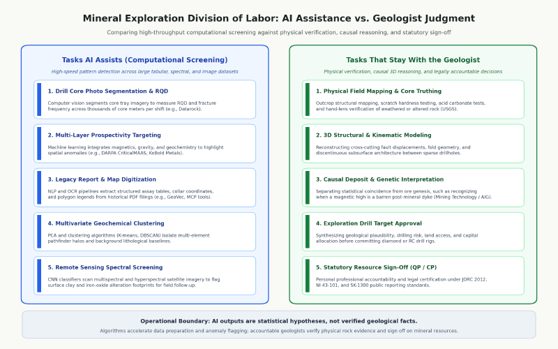
Despite advancements in computational pattern matching, algorithms possess fundamental cognitive limitations when applied to subsurface geology. The professional partnership of ai and geologists remains indispensable because software cannot replicate physical field observation and causal scientific deduction. Examining whether will AI replace geologists reveals that algorithms identify spatial patterns but cannot provide causal geological reasoning.
Industry investigations by Mining Technology, citing technical discussions with the Australian Institute of Geoscientists (AIG) and USGS researchers, emphasize that AI systems cannot evaluate whether a statistical correlation honors physical geology. For example, a machine learning model can easily identify a strong spatial correlation between high magnetic responses and elevated copper grades.
However, an algorithm cannot determine whether that magnetic signature originates from primary copper-bearing magnetite or a young, unmineralized post-mineral dyke that cross-cuts and destroys the mineralized deposit. Therefore, a human geologist must evaluate this distinction by inspecting cross-cutting relationships in outcrop mapping, examining diamond drill core textures, and verifying paragenetic mineral sequences.
Decision Protocol for AI and Geologists in Exploration
To prevent expensive exploration blunders, exploration teams establish clear decision protocols that define when computer predictions can be accepted or refuted. Specifically, the table below outlines these evaluation stages:
| Exploration Stage | Algorithmic Output | Geologist Decision Protocol | Definitive Verification Method |
|---|---|---|---|
| Geophysical Anomaly Screening | Coincident magnetic high and gravity response | Interrogate regional structural context to rule out post-mineral barren intrusions | Surface geological mapping, structural cross-sections, and oriented diamond drilling |
| Multivariate Geochemical Domaining | Clustered assay anomalies highlighting potential alteration halos | Verify elemental associations against physical mineralogy and weathering profiles | Petrographic thin-section analysis, hand-lens logging, and laboratory duplicate assays |
| Implicit Wireframe Modeling | Interpolated high-grade mineralized shells across boreholes | Enforce structural fault boundaries and kinematic displacement geometries | Structural strike-and-dip audits and balanced sectional interpretation |
| Statutory Resource Estimation | Automated block model grade distributions | Audit geological domain boundaries, variogram models, and data provenance | Qualified Person (QP) formal sign-off under statutory reporting codes |
Statutory Accountability: Can AI Replace Geologists Legally?
Furthermore, statutory accountability enforces a strict legal boundary between computational calculation and professional liability. Mineral resource estimates published on capital markets must be certified by an accountable professional:
- Australasia (JORC Code): For instance, requires a Competent Person (
CP) with minimum five years of relevant mineral style experience to sign public release documents. - Canada (NI 43-101): In addition, mandates that an accredited Qualified Person (
QP) accepts personal professional and legal responsibility for scientific reports. - United States (SEC S-K 1300): Similarly, requires formal sign-off by a licensed Qualified Person registered with recognized professional organizations.
Because algorithms possess zero legal liability, they cannot stand before statutory regulators or corporate audit committees. Therefore, final exploration and resource decisions remain strictly with licensed human geoscientists.
As demonstrated in our blind rare earth test with field validation needed at Coe Fairbairn, machine learning models can generate prospective targets from regional datasets, but confirming economic mineralization strictly requires direct field drilling and physical sample validation.
Without direct field verification, exploration companies risk committing millions of drilling dollars to false statistical artifacts. Therefore, experienced exploration geologists prevent these expensive failures by auditing computer recommendations against fundamental structural and geochemical principles.
Is There a Geologist Shortage? Workforce Demographics and Reality
Concerns that automation will eliminate exploration careers contrast sharply with empirical labor data, which highlights a widespread geologist shortage across major mining jurisdictions. Demographic analysis indicates that the mineral exploration sector faces severe personnel deficits driven by an aging workforce and shrinking educational pipelines.
According to workforce studies by the American Geosciences Institute (AGI, 2024), approximately 27% of the total United States geoscience workforce reaches retirement eligibility by 2029. This impending retirement wave threatens to remove decades of practical structural and economic geology experience from exploration teams.
In addition, employment forecasts from the US Bureau of Labor Statistics (BLS, 2024 to 2034) project a 3.2% employment growth rate for geoscientists, expanding the baseline of 25,100 professionals. This sustained demand is driven by the global transition toward domestic critical mineral supplies and renewable energy infrastructure.
Is There a Geologist Shortage? Primary Workforce Data
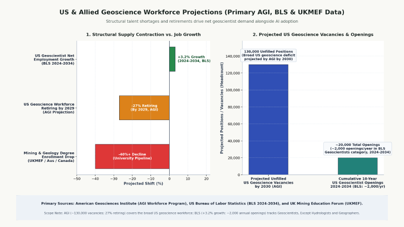
The table below summarizes primary geoscience workforce metrics alongside their direct evidential limits:
| Demographic Metric | Measured Statistic | Sourced Institution & Geographic Scope | Limitations as AI Impact Evidence |
|---|---|---|---|
| US Geoscience Retirement Cliff | ~27% reaching retirement eligibility by 2029 | American Geosciences Institute (AGI, 2024 Report) | Measures broad geoscience retirement eligibility, not mineral exploration geologists specifically. |
| Projected US Geoscientist Deficit | Up to 130,000 unfilled vacancies by 2030 | AGI Workforce Program & Mining Technology (2024) | Represents a broad sectoral talent gap across energy, water, and environmental fields. |
| US Geoscientist Employment Outlook | +3.2% projected growth (2024 to 2034) | US Bureau of Labor Statistics (BLS, 2024–2034 Forecast) | Reflects baseline macro hiring across 25,100 professionals; does not isolate AI task elasticity. |
| Academic Enrolment Contraction | >40% decline in mining and geology degrees | UK Mining Education Forum (UKMEF, 2024 Report) | Enrolment contraction reflects student career preferences rather than employer AI automation rates. |
Why Workforce Constraints Drive AI Adoption: Will AI Replace Geologists?
Compounding this demographic retirement cliff, the UK Mining Education Forum (UKMEF, 2024) documents a contraction of greater than 40% in mining engineering and geology university enrolments across the United Kingdom, Australia, and Canada over the past decade. Consequently, universities are not producing enough graduates to replace retiring senior practitioners.
Workforce demographic projections illustrate that asking will AI replace geologists inverts the primary operational constraint facing mining companies today. While demographic shortages demonstrate that mining companies adopt AI to maintain project momentum rather than downsize payroll, macro labor statistics cannot prove that automation will never compress specific task categories. As a result, industry adoption of AI represents an operational necessity to manage expanding data volumes with leaner technical teams.
How Work Is Changing: The Future of Geology Jobs
The integration of computational workflows is actively reshaping the future of geology jobs across the mineral exploration lifecycle. Rather than asking will AI replace geologists, exploration managers are examining how to equip their teams with digital workflows. Instead of eliminating professionals, digital tooling shifts the geologist’s role from manual data compiler to algorithm supervisor, data provenance auditor, and ground-truth verification specialist.
Rather than spending months transcribing assay logs into spreadsheets, modern geoscientists manage multi-source digital pipelines. Specifically, teams require professionals who understand how algorithmic models generate predictions and where mathematical assumptions break down.
Three Operational Stages for the Future of Geology Jobs
To manage machine learning workflows responsibly, exploration teams structure their operational pipeline across three sequential stages:
- Stage 1: Data Preparation and Spatial Splitting (Before AI): Geologists audit input databases for spatial autocorrelation. In particular, they ensure training and testing datasets avoid spatial leakage, where nearby drillholes artificially inflate model accuracy scores.
- Stage 2: Algorithmic Parameterization and Scoring (During AI): In addition, geologists supervise computer vision and spatial targeting models, setting boundary constraints and logging model hyperparameter configurations.
- Stage 3: Geological Reconciliation and Drilling Sign-off (After AI): Finally, geologists audit candidate targets against mapped outcrop structures, verify data provenance, and design physical diamond drilling campaigns.
Verifiable Audit Trails: How AI and Geologists Collaborate
To explore how modern software facilitates traceable geological workflows without displacing professional interpretation, examine AI for geologists using the browser-based GeoCluster research harness. For instance, GeoCluster maintains transparent links between raw observations and extracted spatial features.
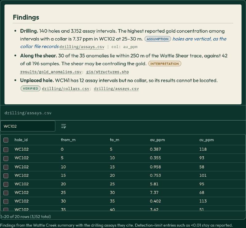
Geoscientists can also review our technical evaluation of AI mining software for geologists to see how modern platforms handle multi-element geochemical and geophysical data streams. By enforcing strict data provenance, geoscientists ensure that algorithmic outputs can withstand external audits and regulatory reviews.
What Early-Career Geologists Should Do
Students and early-career geologists entering the mining industry often wonder whether is geology a good career ai integration is reshaping. In practice, automated tooling increases industry demand for hybrid geoscientists who combine rigorous field mapping skills with digital data fluency. The most resilient exploration professionals will not be pure computer programmers or hammer-only traditionalists, but geoscientists who can ground-truth algorithmic outputs.
Four Core Competencies for Early-Career Geoscientists
To build a durable career in mineral exploration, early-career practitioners should structure their development across four practical competencies:
- Master Core Logging and Outcrop Mapping: In particular, field mapping, measuring structural orientations with a compass-clinometer, and hand-lens rock identification remain irreplaceable foundational skills. For example, an algorithm cannot correct flawed primary lithological observations.
- Develop Spatial Data and Scripting Skills: For instance, learn practical tabular and spatial data manipulation using Python libraries like
pandas,geopandas, andshapely. In addition, understand coordinate reference systems (CRS) to prevent costly spatial projection errors. - Learn Analytical QA/QC and Model Auditing: Furthermore, master industry quality assurance protocols, including the insertion of certified reference materials (
CRM), field duplicates, and blank samples to ensure assay integrity. Consequently, learn to test spatial predictive models for over-fitting. - Practice Professional Skepticism Toward Black-Box Maps: In addition, develop the habit of interrogating computer predictions by checking whether raw physical measurements support automated target scores before recommending drill expenditures.
Four-Stage Competency Roadmap for Early-Career Geologists
The table below outlines a practical learning roadmap for developing hybrid geological and computational capabilities:
| Development Stage | Primary Geological Focus | Computational Competency | Practical Verification Action |
|---|---|---|---|
| 1. Foundational Field Skills | Outcrop mapping, compass-clinometer dips, and core logging | Basic GIS data visualization and coordinate transformations | Ground-truth primary lithology descriptions against physical rock samples. |
| 2. Data Manipulation & Python | Spatial coordinate consistency and geochemical databases | Tabular data manipulation using pandas, geopandas, and shapely | Audit spatial data tables and verify collar coordinates across coordinate systems (CRS). |
| 3. Model Auditing & QA/QC | Geological quality assurance and duplicate assay validation | Evaluating spatial leakage, false positives, and cross-validation splits | Check certified reference materials (CRM) and blanks to validate assay accuracy. |
| 4. Structural & Statutory Reporting | Kinematic cross-sections and 3D deposit architecture | Interrogating implicit wireframe interpolation parameters | Ensure 3D models honor mapped structural cutoffs under JORC, NI 43-101, or S-K 1300. |
Practitioners looking to broaden their computational understanding can explore our collection of AI geology tooltips for practical explainers on coordinate transformations, geochemical clustering, and drillhole data validation.
Operational Risks and Limitations of Exploration AI
Deploying machine learning models in mineral exploration introduces distinct operational and geological risks that teams must actively manage. Understanding why will AI replace geologists remains an inaccurate prediction requires examining the limitations inherent to machine learning algorithms. Over-reliance on unverified algorithmic predictions can misdirect exploration capital and erode foundational geological competence.
Four Core Operational Risks in AI Exploration
Specifically, to protect exploration budgets and maintain technical integrity, exploration organizations manage four primary operational risks:
- Uncritical Acceptance of False-Positive Target Anomalies: Machine learning models can easily generate compelling visual prospectivity maps based on statistical noise or spatial sampling bias. For example, exploration samples often cluster near access roads, leading naive models to associate road proximity with mineralization unless spatial de-biasing is enforced.
- Structural Vein Smoothing in Implicit Wireframing: Implicit 3D modeling algorithms using global radial basis functions frequently smooth out narrow, high-grade structural veins or miss discontinuous fault offsets. Therefore, interpreters must manually enforce structural cutoffs and geometric balancing rules.
- Degradation of Fundamental Observational Competence: If junior geologists rely entirely on automated core logging software, they risk failing to develop the intuitive rock-identification and alteration-mapping skills needed for senior interpretation.
- Lack of Data Provenance and Traceable Audit Trails: When proprietary algorithms transform raw assay numbers into opaque prospectivity scores, companies lose the ability to defend targets to statutory regulators or investment committees.
Risk Mitigation Matrix for AI and Geologists in Exploration
The table below illustrates engineering mitigations designed to counter these operational risks:
| Operational Risk | Algorithmic Mechanism | Geological Consequence | Standard Engineering Mitigation |
|---|---|---|---|
| False-Positive Target Anomalies | Deep learning models fitting statistical noise or road proximity | Wasted exploration expenditure drilling unmineralized country rock | Enforce independent outcrop mapping and geochemical soil sampling before permitting drill pads. |
| Structural Vein Smoothing | Global interpolation algorithms averaging discontinuous intercepts | Underestimating narrow high-grade vein continuity and fault offsets | Apply explicit structural fault wireframes and directional anisotropy constraints. |
| Observational Skill Atrophy | Junior geoscientists relying on automated core logging tools | Decreased institutional ability to identify subtle alteration nuances | Mandate periodic manual core logging audits and mentor-supervised field mapping camps. |
| Opaque Data Provenance | Black-box transformation of raw sensor feeds into targeting scores | Inability to defend mineral resource models to statutory regulators | Enforce version-controlled data pipelines and immutable raw analytical audit trails. |
FAQs
Will AI replace geologists?
Addressing whether will AI replace geologists, industry evidence indicates that artificial intelligence will not eliminate the geology profession. While machine learning automates repetitive data formatting, core photography classification, and preliminary geophysical anomaly screening, discovering deposits requires physical field mapping, structural interpretation, and statutory sign-off. Consequently, algorithms augment exploration geologists rather than replacing accountable human judgment.
Which geology tasks can AI automate?
Artificial intelligence automates repetitive, rule-based geoscience tasks under defined operational constraints. These include segmenting continuous core photography, calculating visual rock quality designation, extracting tabular assay records from scanned historical PDFs, and clustering geochemical suites. However, selecting drill targets, resolving structural cross-cutting relationships, and certifying mineral resource estimates require experienced geologists.
Is geology a good career with AI?
Evaluating whether is geology a good career ai integration reveals strong long-term fundamentals for data-literate professionals. Retiring senior staff across major mining nations and growing critical mineral demand create sustained employment demand. Geologists who combine solid field mapping foundations with digital data management, spatial Python scripting, and algorithm auditing skills are particularly well positioned.
Is there a shortage of geologists?
Yes, demographic studies in major exploration jurisdictions reveal acute geoscience workforce shortages. The American Geosciences Institute reports that approximately 27% of the US geoscience workforce reaches retirement eligibility by 2029, while university enrolments have fallen sharply. Exploration companies adopt machine learning tools to maintain project velocity despite constrained technical staffing, rather than to downsize departments.
What skills should a geologist learn for AI?
Geologists should build strong field mapping, structural geology, and core logging capabilities before adding digital skills. Essential computational competencies include manipulating spatial data tables using Python, understanding coordinate reference systems, auditing machine learning prospectivity models for spatial leakage, and enforcing quality assurance protocols across geochemical assays to prevent misleading algorithmic predictions.
Can AI find mineral deposits without a geologist?
No, artificial intelligence cannot discover mineral deposits independently. Algorithmic prospectivity systems identify statistical correlations across regional layers, but cannot differentiate economic mineralization from unmineralized country rock or post-mineral intrusions. Confirming subsurface continuity, directing drill rigs, and verifying assay grades require physical field mapping, core inspection, and accountable geological reasoning.
How should geologists check AI output?
Geologists should evaluate automated model outputs by auditing data provenance, testing spatial training splits, and conducting physical field validation. Essential checking protocols include verifying that input data lacks access bias, ensuring structural interpolations honor mapped fault kinematics, and confirming that prospective geophysical anomalies reflect genuine hydrothermal alteration rather than barren magnetic rocks.
Try It With Geocluster
The open-source GeoCluster research harness provides automated tools and agent workflows designed specifically for geological investigation, document parsing, and spatial coordinate verification.
Read our practical guide on how to verify historical drilling data before you use it to validate collar coordinates, downhole deviation surveys, and analytical assay certificates before integrating automated models into your exploration database.