TL;DR
- Most AI for geology stops at correlation. Geological observations are not independent clues, though: they are consequences of one history, so a real relationship should make the rest of the picture easier to explain.
- The discovery of the Ekati diamond mine shows the idea at work. Pathfinder garnets hundreds of miles from any diamond still narrowed the search, because they told a story that could be rewound.
- We build prospectivity models by keeping a relationship only if it makes the whole world model more coherent. A strong correlation that makes everything else harder to explain gets dropped.
Key Takeaways
- Coherence, not correlation strength, decides what stays in the model. A relationship earns its place by making the rest of the geological environment easier to describe.
- Coherence works where ground truth is scarce. When a single new data point can mean a $500,000 drill hole, the way observations fit together is the best evidence available.
- Outliers become informative. If dozens of observations fit one explanation and one does not, either that data is wrong or the explanation is incomplete.
Most AI for geology asks which variables occur together with ore. This post shows how to build a new world model via coherence mapping instead. Geological observations are interconnected, so we combine them into one geological world model, and a relationship earns its place only if it makes the rest of the picture easier to explain.
Mineral systems, mutual information and a little detective work
Geology is like criminal investigation: most of the time you show up after the important events took place, collect the clues, and try to come up with a theory that accounts for them all. The main difference being that the crime scene may be 300 million years old, a kilometer underground and on fire.
Take skarn deposits, one of our major sources of copper. In its textbook form, the recipe is almost suspiciously neat. Put a magma intrusion next to chemically receptive rocks (limestone is the classic example), add heat and hydrothermal fluids, provide structures through which those fluids can move, and the limestone changes. New minerals appear. Garnet and pyroxene grow. Metals move and precipitate. Elements become concentrated. Magnetite appears.
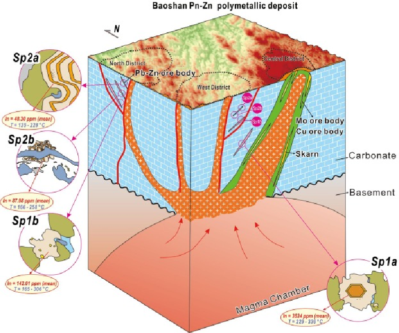
The problem is that we can’t actually see any of it because, spoiler alert, by this point it’s all underground. Your database may tell you that one exploratory drill hole contains anomalous copper, another has garnet. A magnetic survey shows an anomaly nearby. Mapping finds an intrusive contact. Structural interpretation shows a fault through the lot.
These observations are not independent clues that happen to correlate with ore. They are different consequences of the same geological history. It is the geologist’s job to employ inductive reasoning (like Sherlock Holmes, who did not, in fact, deduce anything) to come up with a theory of the crime that accounts for all of these facts.
How Does Inductive Geological World Modelling Work?
When done well this can be spectacular. Ekati is a diamond mine in Canada’s Northwest Territories, about 300 kilometres northeast of Yellowknife. Opened in 1998, it was Canada’s first diamond mine. Its discovery followed roughly a decade of systematic exploration by geologists Chuck Fipke and Stewart Blusson, culminating in the drilling of the first diamond-bearing kimberlite pipe at Lac de Gras in 1991.
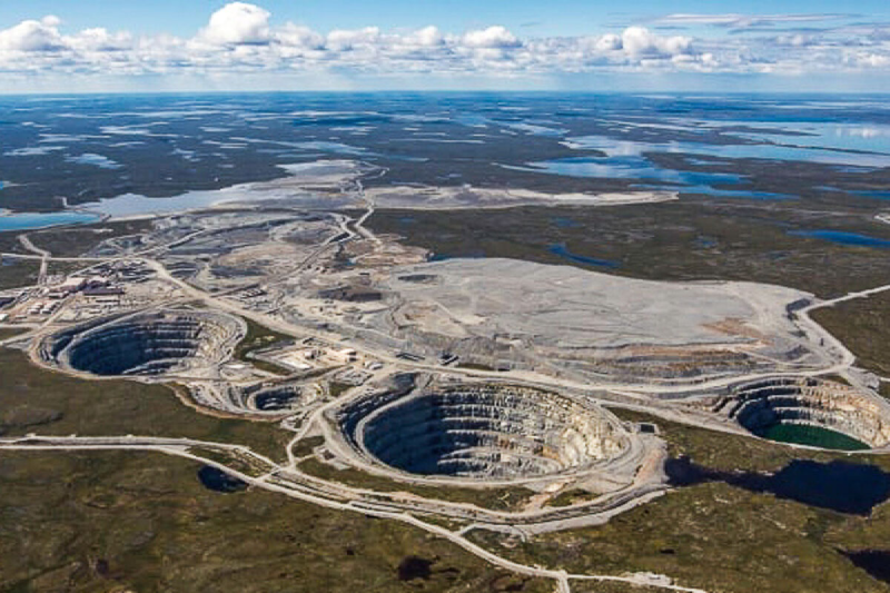
Fipke and Blusson were not simply fossicking for diamonds. Diamonds are hard to find not only because they are rare, but because they are carried up from the depths via long, thin columns of magma that are almost invisible at geological scale: just a few hundred feet across. You could be sitting on one now and not know it.
However, Kimberlites do not carry only diamonds. Their violent journey from the mantle brings up a menagerie of other minerals: chrome-rich pyrope garnets, chrome diopside, ilmenite and chromite among them. Some have chemical compositions characteristic of the extraordinary pressures and temperatures at which diamonds can survive. They are vastly less valuable than diamonds, but there are more of them.
Fipke and Blusson had noticed that these pathfinder minerals, and even the occasional diamond, were spread across the North American continent in a telling pattern. It suggested that ice age glaciers had sanded the top off a Kimberlite pipe and carried the residue with them. They could thus use the chemistry of individual mineral grains and reconstructed ice-flow directions to follow the dispersal trail back toward its source: tracking the criminal’s footprints to his lair.
When the discovery was confirmed it created a $100m mine and turned Yellowknife into a boomtown where even the lumber shops selling the stakes used to peg claims got rich.
How Can Coherence Reveal Geological Truth?
Fipke and Blusson’s breakthrough was not built on verifying the truth of a specific relationship (the fact that garnets are associated with Kimberlite pipes). It came from understanding that the presence of garnets in an area implied a particular story. Not that there must also be diamonds, but that the garnets had been brought there from a place that also had diamonds, and it would be possible to use them to rewind that process.
Most of the garnets they sampled were hundreds of miles from the nearest diamond, and yet they all helped to narrow the search space.
One causal history, many clues
The garnet, the diamond, the kimberlite, the chemistry of the mantle and the direction of Pleistocene ice flow were not independent facts. They were fragments of one causal history. Understand enough of that history and one observation begins to tell you something about another.
Thus the question is not “Which variables correlate?” (the point at which many AI geology models stop). Rather it is “What proposed relationship makes these observations make more sense together than they did separately?”
If two observations really are consequences of the same underlying geological process, discovering the correct relationship between them should make the environment easier to describe. Knowing one should tell us something about the other. Add a third genuine consequence of the same process, and the description should improve again.
Conversely, an accidental correlation may fit a few observations without making the rest of the geological environment any more coherent.
Correlation, prediction and coherence ask three different questions, and only the last separates a real relationship from an accidental one:
| Approach | The question it asks |
|---|---|
| Correlation | Do these things occur together? |
| Prediction | Does knowing this help us guess that? |
| Coherence | Does this relationship make the world as a whole easier to explain? |
Truth leaves an information-theoretic signature
Our thesis is that geological truth leaves an information-theoretic signature: real relationships allow more of the observed environment to be explained with less independent information.
If a proposed relationship captures real structure in a mineral system, incorporating it should make the observed environment more coherent. Some things that previously had to be described independently can now be explained in terms of one another. A useful hypothesis therefore does more than correlate with mineralisation. It reduces uncertainty elsewhere in the model.
No feature determines the others perfectly (geology is much too unruly for that), but each reduces our surprise about some of the rest. We have acquired an explanation and the world has become cheaper to describe.
Instead of saying “we found garnet at 63°59'31.4"N 122°59'08.0"W, 65°04'05.8"N 125°57'53.4"W, 64°44'15.0"N 111°15'05.4"W…” you can now say “Glaciers left a trail of garnet from a Kimberlite pipe near Yellowknife as far as the Northwestern NT.” It gives much more useful information and is also far shorter.
How Can Coherence Become an Objective Function?
Modern economic geology increasingly thinks in terms of mineral systems: not simply deposits, but the larger physical processes that create them. A mineral system has sources, pathways, chemical and physical traps, and preservation. What eventually becomes an orebody is one local expression of that history.
A fault, an alteration halo and an unusual elemental ratio may look like three different observations. If they are products of the same mineral system, however, they are not independent. Each encodes a little information about the others. In other words, the system is the thing and the anomalies are shadows it casts.
When ground truth costs a drill hole
This gives us a starting point for evaluating data even when there is little or no ground truth available to check against. In exploration, obtaining a new piece of ground truth might mean drilling a $500,000 hole. If dozens of independent observations fit together into one geological explanation while another contradicts it, that contradiction becomes informative in its own right. Either the outlier is wrong, or it is telling us that our explanation of the system is incomplete.
World modelling as a combinatorics problem
Under this assumption, world modelling becomes a pure combinatorics problem: how can we combine the datasets we have in such a way as to produce the shortest possible description of the area of interest?
Suppose we have one dataset showing a relationship between bismuth and gold deposits, another saying that gold is associated with greenstone, and a third saying that it is concentrated along a particular fault line. If all three relationships are correct descriptions of the world, a model combining all three should be more informative than the sum of each in isolation, even after applying controls for over-specification. In other words:
- Because observations arise from a common physical world, an accurate description of one part should improve our ability to describe other parts. Knowing about glaciers helps us explain the garnets. Knowing about garnets helps us spot Kimberlites.
- A hypothesis gains credibility when it makes independently observed parts of the same world more mutually informative.
This is the foundation of our approach: we build a new world model via coherence mapping. Given a new regional dataset, our AI sifts through it, running hundreds or thousands of regressions to identify relationships within the data. However, it does not stop there.
What Does a Coherent World Model Look Like?
The word model can be slightly misleading here. We are not trying to build a Minecraft version of the underground, with every rock placed in its supposedly correct location. Actually, it’s more like a set of clouds of probabilities.
Imagine that gold, bismuth, greenstone and proximity to a particular fault each occupy positions in this abstract space. Discovering that gold reliably occurs with bismuth draws those observations closer together: knowing one now tells us something about the other. If gold is also associated with greenstone, and both are concentrated around the same fault system, those relationships reinforce one another. A previously scattered collection of observations begins to acquire structure.
But now suppose our bismuth dataset is wrong. Perhaps the instrument was poorly calibrated, the coordinates were shifted, or the samples came from a different population. We might still find an apparently strong gold–bismuth relationship in part of the dataset. If we considered that relationship alone, it could look convincing.
Once we add it to the world model, however, something goes wrong. Pulling gold towards bismuth pulls it away from relationships that already explain the greenstone, structure, alteration and other observations. We have made one corner of the model neater at the cost of making the whole thing less coherent.
A relationship therefore does not earn its place by being strong, rather it earns its place by making the rest of the world make more sense.
The Reality Test
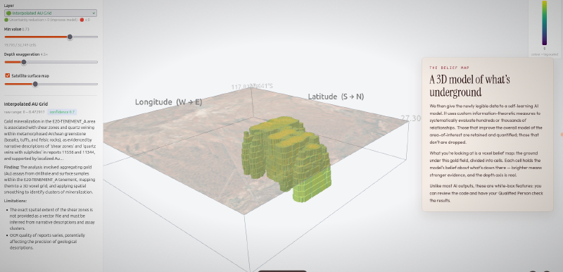
This is the approach we use at Eigenform for mineral prospectivity mapping on real exploration data. You can explore it in our interactive voxel case study and on the prospectivity map demo.
We’ve used this approach on exploration projects in Australia and Central Asia. There are a great many mineral systems left to understand.
If you think yours might be one of them, talk to us.
Conclusion: What It Takes to Build a New World Model via Coherence Mapping
To build a new world model via coherence mapping, treat geological observations as consequences of one history rather than independent clues. Test each proposed relationship by what it does to the rest of the model. A real one makes other observations easier to explain; an accidental one does not.
That turns coherence into an objective function that works even where ground truth costs a drill hole, and it turns outliers into evidence. The shift from correlation to models that explain the whole system is one of the macrotrends in AI for mineral exploration we track.
FAQs
What is coherence mapping?
Coherence mapping is a form of coherence-based modelling: it builds a geological model by keeping only relationships that make the observations easier to explain together. Instead of asking which variables correlate with ore, it asks whether a proposed relationship reduces uncertainty elsewhere in the model. Relationships that make the whole picture more coherent stay; the rest are dropped.
How does coherence mapping work in mineral exploration?
Our AI runs hundreds or thousands of regressions over a regional dataset to find candidate relationships, such as gold with bismuth or with a fault system. Each one is then tested against the rest of the world model. It stays only if it makes the other observations more mutually informative. The result is a voxel belief map of prospectivity.
What is a geological world model?
A geological world model describes how the observations in an area fit one geological history: sources, pathways, traps and preservation. Ours is not a rock-by-rock reconstruction of the underground. It is closer to clouds of probability, where related observations sit closer together and each relationship reduces uncertainty about the others.
How does coherence differ from correlation?
Correlation asks whether two things occur together. Coherence asks whether a relationship makes the whole picture easier to explain. A strong correlation can still be wrong: a miscalibrated bismuth dataset may show a convincing gold link that pulls the model away from relationships that already explain greenstone and structure. Coherence catches that; correlation alone does not.
How can AI build a geological world model?
By searching combinations of datasets for the shortest description of an area. The AI proposes relationships from the data, then keeps the ones that make independently observed parts of the area more mutually informative, with controls for over-specification. World modelling becomes a combinatorics problem, and outliers show where the data or the model is wrong.
How can mineral exploration AI work with limited ground truth?
By using how observations fit together as evidence. A new piece of ground truth can mean a $500,000 drill hole, so labels are scarce. If dozens of independent observations fit one geological explanation and one contradicts it, the contradiction is informative: either that data point is wrong or the explanation is incomplete.